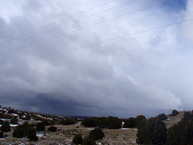
I first noticed the squalls as I was leaving Santa Fe via I-25, and I stopped at the exit near the top of La Bajada Hill to take a couple pictures. This picture shows the strongest cell:
As I had gotten on I-25 from route 599, I had noticed that this cell had an impressive cauliflour top just beginning to glaciate at its northern end, though much more glaciated to the south where the heaviest snow was falling. But there was no place to exit where I could see this well, so it was more obscured where I took the picture above. Still, it was evident that this cell, more or less to my west, was producing very heavy snow. The next cell up the line to the northeast was also fairly strong, and had a feature resembling a shelf cloud along its leading edge.
As I proceeded southwest on I-25, I skirted the edge of this cell in the area around La Bajada Hill, encoutering graupel, then snow, then graupel again, then finally a few larger chunks of something that sounded harder, just on the edge of the cell before I cleared the precipitation. Could have been very large snow pellets - I once was out in ones a half-inch in diameter in Colorado - but from the size and sound they made when they hit, I think hail is more likely - or perhaps some hybrid form of precipitation intermediate between graupel and hail. By now, I had a very good view of the updraft area of this cell, which seemed at the time to be at the tail end of the line, along with its precipitation shafts, so I stopped at the Santo Domingo Pueblo exit for a couple more pictures:
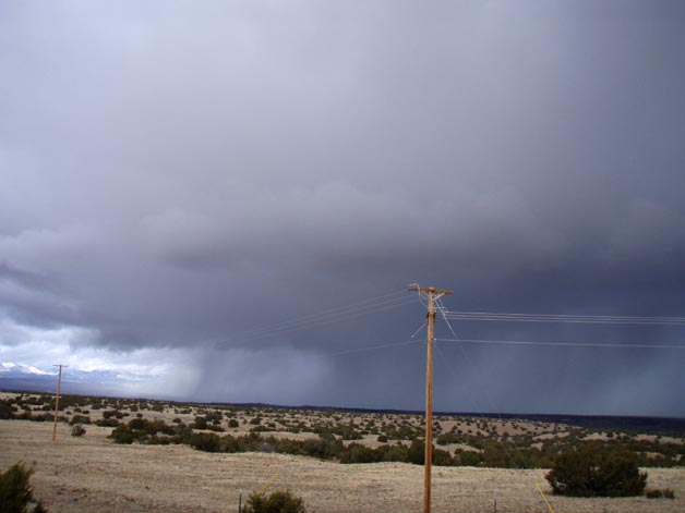
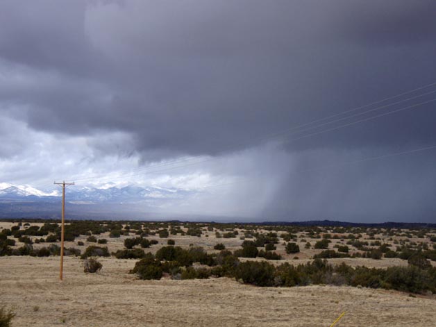
In the first picture above, you can again see a shelf-cloud type feature along the leading edge of the precipitation core, and both pictures show both the updraft base (I guess you could call it "snow-free base") and the intense precipitation shafts. The snow-covered mountains in the background are the Jemez mountains, where snow totals over the five days exceeded 2 feet. When I took these pictures, the cell was passing over the Cochiti Pueblo area, and the snow and snow pellets must have been coming down very intensely there. I half expected to see flashes of CG lightning from the appearance of the squall, but did not, even though 1) I had experienced thundersnow with another squall in Santa Fe the evening before and 2) a cell in the next line southeast of this one did eventually produce some lightning strikes.
As I headed on to the airport, I noticed another line of snowshowers ahead of this first one, with a fair-sized area of precipitation beginning to move into the Albuquerque area. Between Bernalillo and the Tramway Blvd exit, I ran into the precipitation, and from there to about Central Avenue I was in snow, then graupel, and finally, just before I cleared the precipitation, what I am quite sure was some small hail. For a couple miles, the graupel totally covered the road, slowing traffic to about 40 mph. Right before I cleared the precipitation, the sound it was making suddenly changed and became louder and harder-sounding, even though the size of the chunks appeared to be about the same - thus I am quite sure that at this point it was ice, not snow pellets. Since the type of melting then re-freezing associated with sleet was not consistent with the temperature profile, and since I encountered no rain, I think that what I encountered here was hail, not sleet, though I am not sure. However, my impression is consistent with a media report of "peanut sized hail" a few miles east of my location, though what I encountered there was not that big.
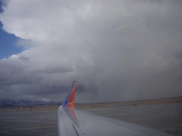
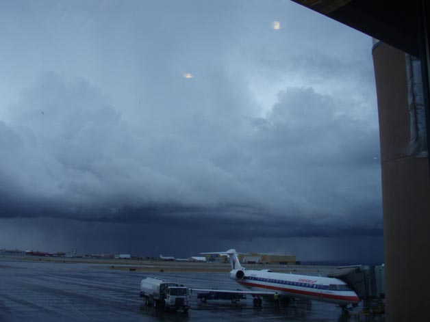
In any case, shortly after I arrived at the airport, the line passed over and produced a brief burst of snow, though not nearly as heavy as I had come through, as that cell passed northeast of the airport. However, as I waited for my plane I observed the following intense squall that formed down the line to the southwest of the airport:
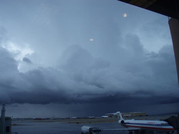
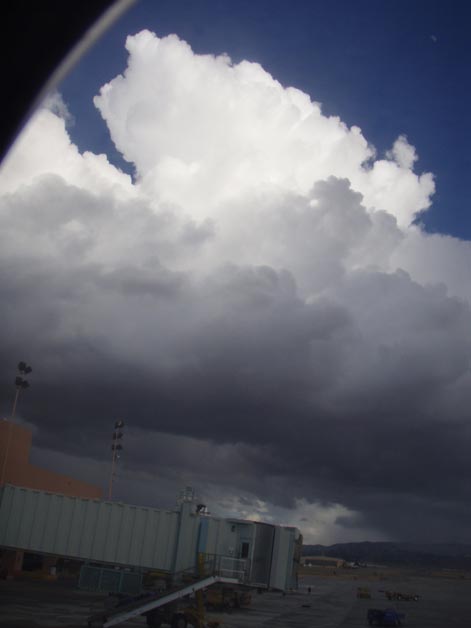
A less zoomed view showing what appeared to be a new cell merging into this one can be seen here. Around the time I took these pictures, I noticed on my computer (the ABQ airport has free wi-fi - yay!) that Weathertap was showing a couple fresh lightning strikes as the cell I had driven through in Albuquerque moved into the Manzano Mountains southeast of the city. As the cells in the pictures just above moved into the southern end of the Manzano Mountains a little later, I noticed from my plane that a very distinct anvil had developed:
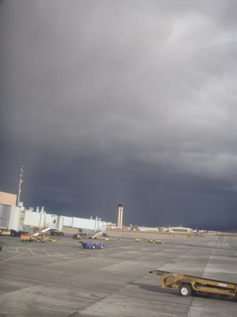
Note also the rather intense shafts of snow that you can see under the cell. At the same time, a second broken line (maybe some backbuilding from the same one I had observed earlier near Santa Fe and Cochiti) was moving into the east side of Albuquerque from the northwest. In the following two pictures, you can see an updraft tower associated with that line and, shortly later, the intense burst of snow and/or graupel that formed under it:
We then took off for a flight that, unsurprisingly, started out rather bumpy. I have always been impressed by the extent to which, under the right conditions, winter snow showers can visually resemble summer thunderstorms. But I have never seen that to a greater extent than was the case on this day. Of course, at least one of these snow squalls WAS a thunderstorm, but even the ones that apparently produced no lightning certainly had the look.