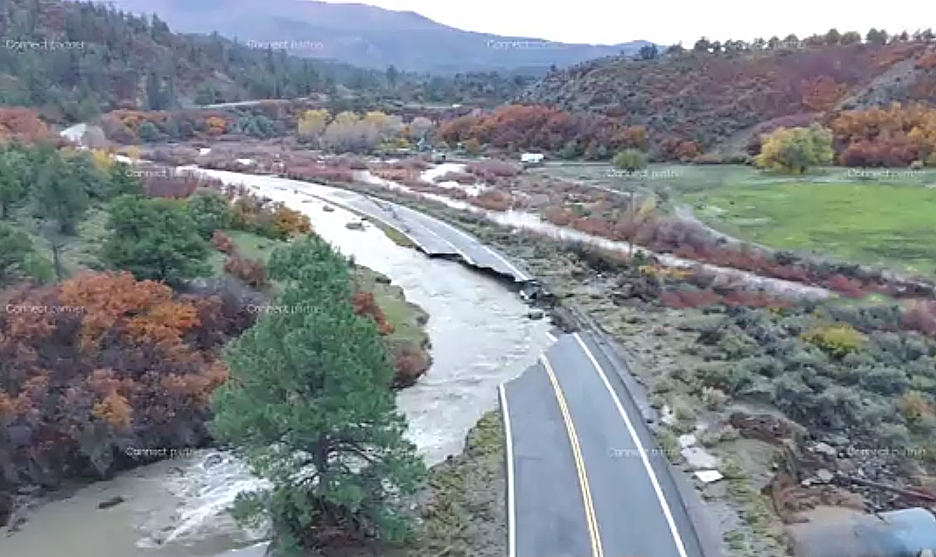
The flooding was particularly destructive. In Archuleta County, Colorado, which includes Pagosa Springs where I live, damage was estimated to be at least $90 million, with more than 800 structures, including more than 500 homes, impacted by the flooding. Numerous roads were washed out, with 150 miles of roadway closed nearly a week after the flooding. US160, the main east-west route across Colorado, was closed in numerous places due to road damage from the floods, with scattered closures all the way from near South Fork to near the Four Corners Monument. There were closures of US 160 in Rio Grande County, Mineral County, Archuleta County, and San Juan County. For a time, you could not go either east or west on 160 from Pagosa Springs, and there were closures on both sides of Wolf Creek Pass. Here is a picture from the Colorado D.O.T. of Colorado Highway 151 southwest of Pagosa Springs:
This highway goes from Chimney Rock National Monument to Arboles, CO and Navajo Lake. It remains closed and will for a while, as it was totally washed out in two different places.
Farther southwest, the devastation from the flood was even greater. News reports indicated that 2,500 homes were impacted by the floods in the Farmington-Bloomfield-Aztec area in San Juan County, New Mexico, with water overtopping multiple bridges. Many people had to be rescued by helicopter in Archuleta County, CO and San Juan County, NM. This included people who were stranded in their homes by floodwater, people who had to be rescued after driving into flooded areas, and people who were trapped because the only way in and out of their homes was either flooded or washed out.
Major damage from flooding also occurred on the Navajo Reservation in northwest New Mexico and northeast Arizona, and in multiple towns along the San Juan River and its tributaries in Utah. Towns that were impacted included Montezuma Creek, UT, Bluff, UT, and Mexican Hat, UT. While these towns were impacted by the San Juan River, there was major flooding elsewhere in Utah as well, with many homes flooded in Hurricane, UT, not far from Zion National Park, which was also impacted by flooding.
In addition to the widespread flooding and the tornadoes, this weather system also brought a major hailstorm, accompanied in some places by high wind, to much of the Phoenix, AZ area on October 21. A number of areas experienced heavy barrages of 1.5-2-inch hail, in some locations with wind as high as 60 mph. Hundreds of cars were severely damaged, ending up looking like this one:

(Photo from speedzip.com)
There was also widespread damage to roofs and windows of homes and businesses in the Phoenix area, so it was not by any means just cars. This kind of damage adds up quickly. All told, between the flooding, the tornadoes, the high wind, and the hail, I think it is quite possible, even likely, that this multi-day regional storm will go into the record books as a billion-dollar disaster. Just the damage in the Pagosa Springs area gets it nearly a tenth of the way there, and that was just one small area among many that had major impacts from this storm.
First, the upper low. These Pacific storm systems occur every year, forming over the North Pacific, moving down the west coast of North America, and eventually turning inland. In this case, one of these storms came in immediately behind the moisture from the remnants of the hurricane. This storm was also able to pull in tropical moisture from its south as it neared California, which again was enhanced by El Nino. And it interacted with the initial band of moisture associated with the hurricane, pulling it northward more than it might have otherwise gone. Also, with both this system and the earlier one associated with the hurricane, wind ahead of the incoming system was strong from the southwest at the upper levels of the atmosphere because of the influence of the aforementioned subtropical jet stream. But at the surface, wind ahead of both systems was from the south or southeast. This created directional wind shear - wind blowing in different directions and strenghtening as on goes up from the ground to the upper levels of the atmosphere. This promotes rotation within storms, leading to supercell thunderstorms (storms with rotating updrafts). This increases the likelihood of large hail and tornadoes. Usually this process occurs east of the Rocky Mountains, on the High Plains and into the Midwest and South. But in this case, because of the position of the storms farther west, this process occured near and west of the mountains, instead of east of them.
Both the first storm associated with the remnants of Hurricane Trudy and the second one associated with the Pacific upper low pulled large amounts of tropical moisture (again, associated in part with El Nino) northweard over the Four Corners states, resluting in very high rainfall and in severe weather. And it was not just one storm, but two, with rain and storms from the second one moving over many of the same areas that were impacted by the first storm. This second storm, the Pacific low, traversed the Four Corners region on October 24 and 25, in the immediate wake of the first storm, albeit on a somewhat more northerly track, but still with plenty of storms on its southeast flank extending southward. Finally, there was one other factor - the "blocky" pattern I mentioned. This was caused by high pressure farther east in the United States, which effectively kept these two storm systems from moving across the western states as quickly as they otherwise might have. A slower-moving storm means a longer-lasting storm. It keeps raining, or rains over and over again, for a longer period of time. This increases the total rainfall amounts, in this case, by a lot. You can see that in these two accumulated precipitation maps, showing total rainfall from October 20-29 (almost all of which fell during the October 21-25 time frame):
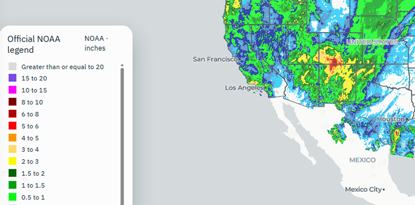
Looking at the map above, you can see that very large proportions of Colorado, New Mexico, and the Texas Panhandle and substantal parts of Utah and Arizona received in excess of 2 inches of rain, and in a number of places, more than 5 inches of rain. Again, nearly all of this fell between October 21 and 25, especially in and west of the Rocky Mountains. That might not be a lot for some wet climates, but for an area that is largely desert, that is a huge amount of rain in that amount of time. More than what is typical for the entire month of October, and in many places, much more.
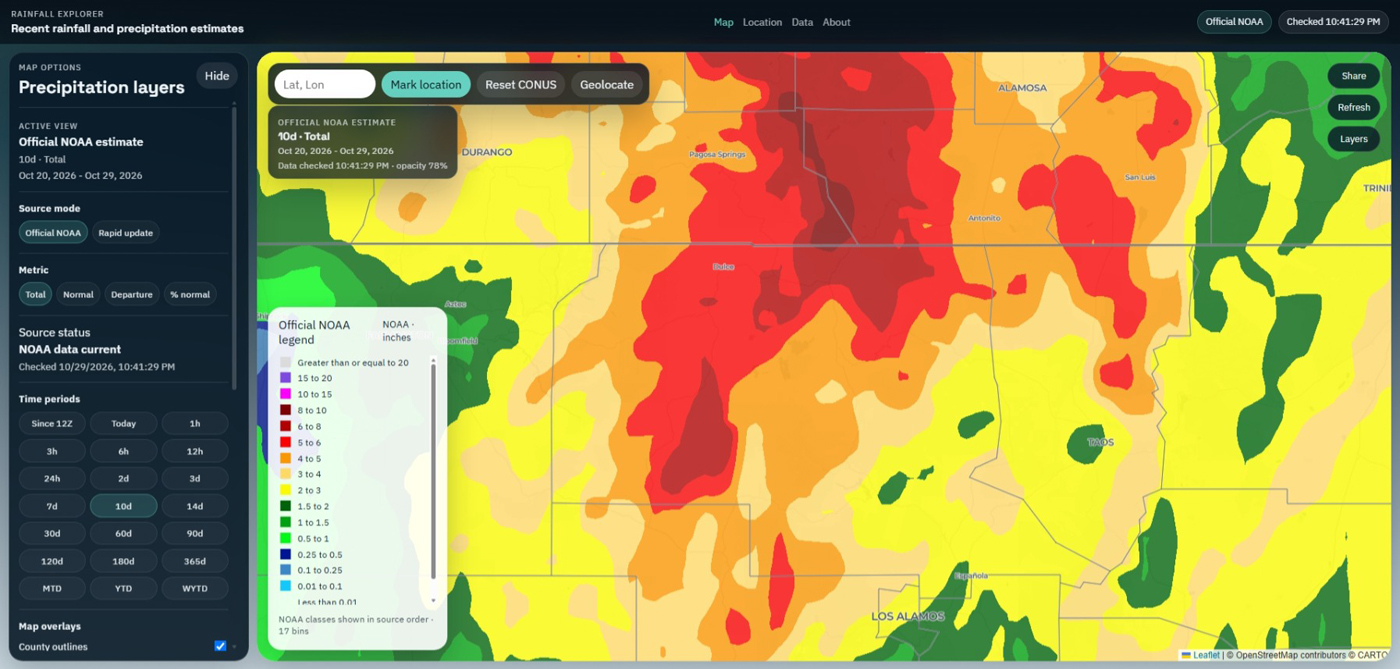
Just how much more? The map above zooms in on southwest Colorado and northwest New Mexico. This is where much of the worst flooding occurred, and much of what occurred elsewhere was downstream from this area. Looking at this map, you can see that everywhere in Archuleta and Conejos Counties in Colorado got at least 3 inches of rain, and much of these two counties got 5 or more inches. These are the two counties that border on New Mexico, about midway between right and left on the upper part of the map. The same is true for much of Mineral and Rio Grande Counties on the north edge of the map, just north of Archuleta and Conejos Counties, and for the sprawling Rio Arriba County in New Mexico, just across the state line to the south. For perspective, the average rainfal for Pagosa Springs in October is around 2 inches, but Pagosa got 4-5 inches of rain on the 21st and 22nd, and up to another inch or so on the 24th and 25th. So a storm total of 4.5 to 6 inches, in a place that normally gets 2 inches all month. And this came on top of 2.5" previously in October and around 6 inches in September. That adds up to a total of around 14 inches in September and October, about triple what is typical. But note one more thing. Nearly everywhere along the Continental Divide in these five counties got at least 5 inches of rain, and many areas got 6-8 inches or more. The part of the Continental Divide from about Wolf Creek Pass southward to the New Mexico state line got 8 inches or more. Yes, some of that came as snow, which reduces the runoff, but in the earlier stages of the storm, much of it came in the form of rain on top of snow that was already on the ground, which increases the runoff. So any way you look at it, that was a lot of water to come down the San Juan River and the Rio Grande and their tributaries. Places like Farmington, NM, Soccorro, NM, and Bluff, UT did not get as much rain, but rain upstream caused major flooding as the flood surge moved down the rivers.
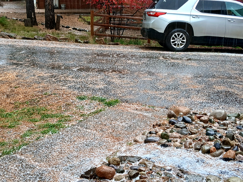
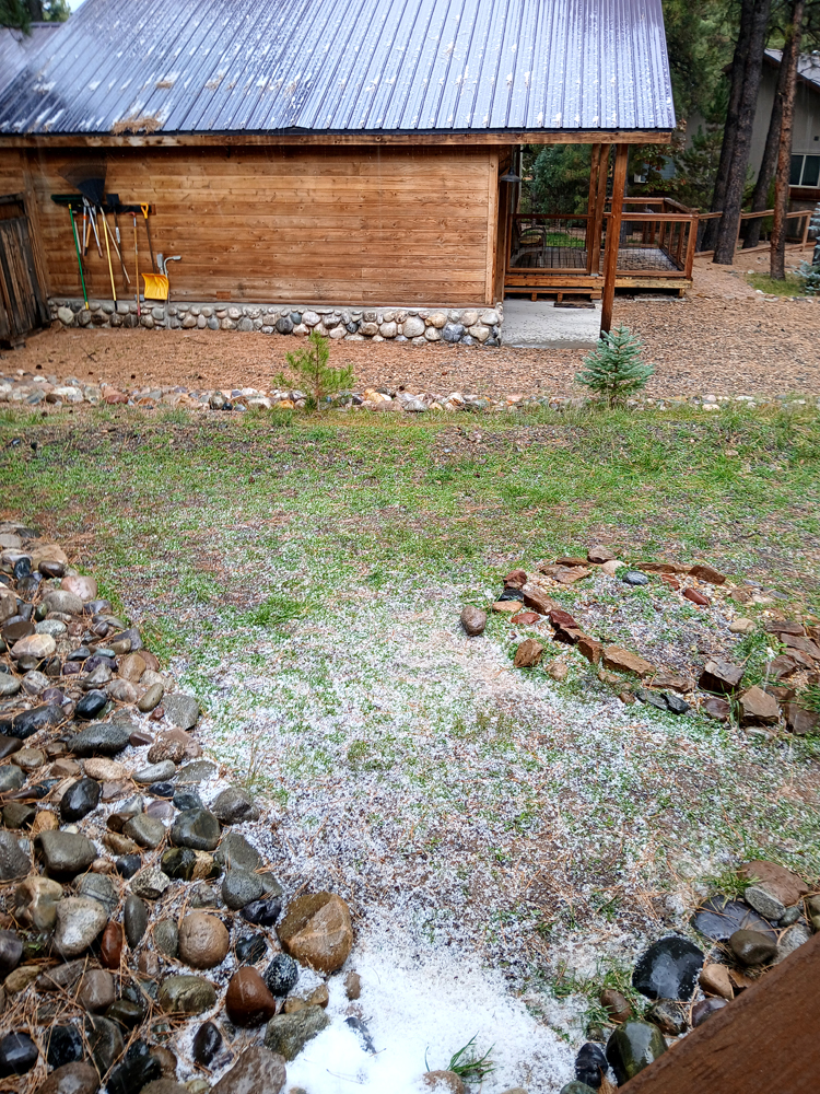
October 21 - As most of northern Arizona to our southwest was under a tornado watch, and experienced severe weather beginning early in the morning, the first thunderstorms associated with this storm reached Pagosa Springs around 1:00 p.m. Some storms in northeast Arizona retained their supercell character, but as they moved into and through the Four Corners region and encountered cooler, less stable air, they began to weaken. So while the threat of severe weather in the Pagosa Springs area was not zero, it was much less than further south. In character with the cooler air around Pagosa, but perhaps also reflecting the influence of earlier rotation in the storm, the first storm that arrived around 1:00 p.m. was mostly hail. It was very small hail, well under the quarter-inch that is considered pea-sized, but a check of the accumulated hail revealed that it was indeed hail, not graupel (snow pellets). The small chunks were hard and icy, in contrast to the softer "styrofoam" texture of graupel. And there was quite a bit of thunder and lightning with this lead storm. Here are a couple pictures of the accumulated hail in our front yard:
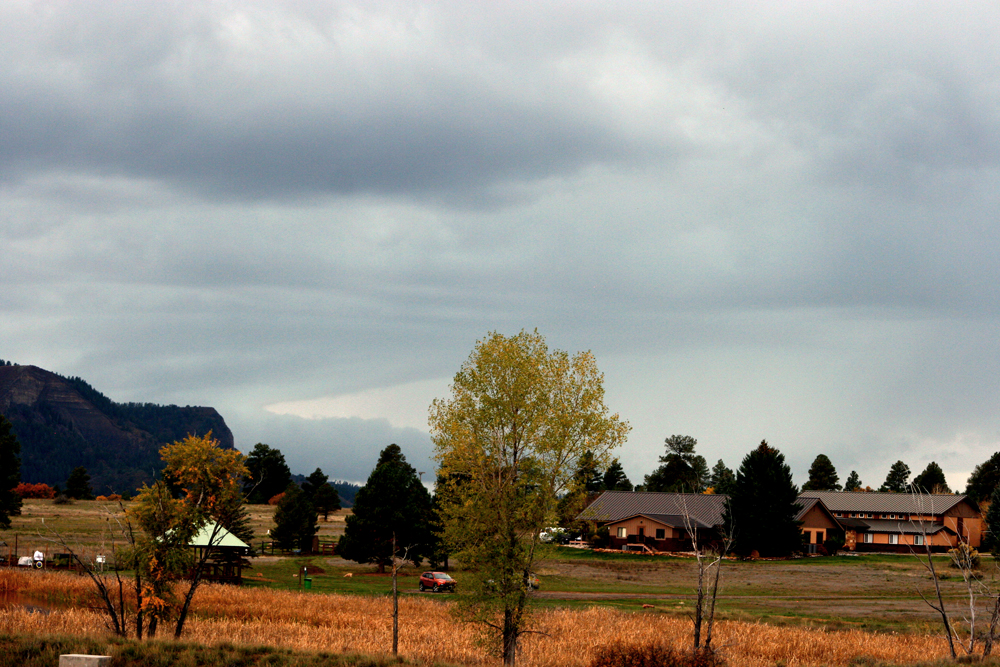
The next storm came in a couple hours later, around 3. This one was a bit more interesting, as it did have some supercell characteristics as it moved northeast into Colorado over Navajo Lake. Some of that structure was evident looking southwest from Veterans Memorial Park in Pagosa Springs, as the storm displayed a nice beavertail as the updraft was about over Navajo Lake or just north of there with the core somewhere not too far from Chimney Rock National Monument:
The storm was also pretty electrified.
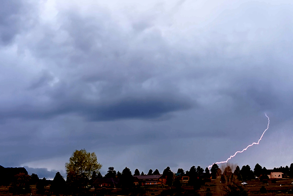
This was probably my favorite picture from this day, as the storm still had the beavertail which, combined with the lightning, made for an intersting picture. However, that was as intersting as this storm got in our area. It gradually morphed into broad area of mostly stratiform rain, with a few rumbles of thunder and then just a steady rain until around maybe 5:00 p.m. After that, it rained off and on through the evening and overnight, addint up to quite a bit of rain, but nothing too dramatic at any given time.
October 22 - This was a harrowing day. We had to drive from Pagosa to Santa Fe, as we had two commitments the following day, and the previous day we could not leave because a home improvement project was being completed. So we had to drive to Santa Fe on the 22nd, regardless of the weather. The overnight rain continued into the morning, becoming gradually heavier. Gradually around 10 or 11, thunder and lightning started up and increased. We had the car loaded and were ready to go around 12:30. After a quick stop at a gas station to grab lunch to take with us, we were on our way. As the radar suggested would be the case, the rain, which was already pretty heavy when we started, became torrential as we neared the New Mexico state line. Visibility was terrible, and I was constantly aware of the possibility of hazards such as standing water or rocks or mud flows going onto the road. Luckily, there was not a lot of that, but there was some of it in spots. About 12 or 14 miles out of Pagosa Springs, the WEA alert on my phone went off for a flash flood warning. This more than verified, as flash flooding soon began all over Archuleta County. On our route, the rain became blinding just before the NM state line, and became mixed with something frozen, either hail or graupel, but then we emerged into some breaks and lighter rain. I thought we might have been past the worst of it, but when we made a brief stop to use the restrooms at the visitor center in Chama, I learned that was not the case. The lady there showed us the radar on her computer, and somewhat to my surprise the leading edge of the storm where the heaviest precipitation was had surged southeast and somehow got back ahead of us again. As we headed south from there, we encountered a stretch where hail had accumulated on the road, which can make the road very slippery, and later a spot flooded with standing water, though thankfully it was worse on the opposite, northbound side of the road than it was on ours. And occasionally some minor mud or rocks that had slid onto the road, but nothing too major. However, with the poor visibility you had to drive rather slowly and constantly be very alert, because hitting any of these obstacles at too high a speed could lead to a dangerous skid. Also, as we entered the intense precipitation on the leading edge of the storm, there was quite a bit of cloud-to-ground (CG) lightning, including one bolt that zapped down only about 1/10 of a mile away. This kind of weather continued to about Ghost Ranch, and then after that it became more scattered with clearing in between the storms. One intense storm went over Espanola ahead of us, but by the time we reached its path, it had moved on to the east. Finally after than we had clear sailing into Santa Fe, and the storms did not advance much beyond Espanola through the evening, though there was some steady light rain overnight in Santa Fe. So long story short, we made it to Santa fine, but it was a very stressful, white-knuickle drive. We found out later that our route flooded multiple places after we had passed through, and for a time parts of it closed. We were fortunate to be able to get ahead of the worst of the flooding, despite the harrowing drive. I have no pictures of any of this, because we were in it most of the time and I was mainly concentrated on making it through. I am a storm chaser and a skier, both of which lead you to drive in some pretty bad weather. But I will say this drive was at least as difficult and harrowing as anything I have done in conjunction with either of those activities for many years.
On this day, in addition to numerous flood watches and warnings in Archuleta County, CO and Rio Arriba County NM, the counties we were driving in, there were also severe thunderstorm watches in southern Colorado and north-central NM. Both Pagosa Springs and Santa Fe were included in one or the other of these, but neither had any severe thunderstorms (large hail or strong wind), despite the severe and widespread flooding that both counties experienced. Farther west, in west-central NM and eastern AZ, there was a tornado watch. However, I am not aware of any tornadoes on October 22. The three tornadoes in Arizona all occurred in the 21st, and the ones in New Mexico were on subsequent days after the 22nd.
October 23 - This was another day we had to do some highway driving, but things turned out to be much calmer. We had to go to Albuquerque for a medical appointment at UNM Hospital, then back to Santa Fe for a fundraising dinner that night at an early childhood school that we support. No weather on the way to Albuquerque, but while we were at the hospital the weather app on my phone alarmed for a severe thunderstorm watch, which included both Albuquerque and Santa Fe. By the time we were on our way back, thunderstorms rapidly developed in two bands, one to our northwest centered on the Jemez Mountains and one to hour east over and along the east slopes of the central mountains, specifically the Sangre de Cristos and the Sandias. These storms moved fairly rapidly to the NNE and both lines did get some severe thunderstorm warnings. Some gusty winds and hail occurred with those lines, but nothing along our driving route and nothing in Santa Fe. Later in the evening, mostly after the aforementioned dinner event, there were thunderstorms in Santa Fe, but nothing severe and no significant flooding. Kind of a down day between the 22nd and the 23rd, but by the 24th, thins would change big time.
October 24 - This turned out to be quite a day in Santa Fe. In the late aftenoon, my best storm chase day of the 2026 season, as illustrated by this picture (one of many I took of this supercell storm):
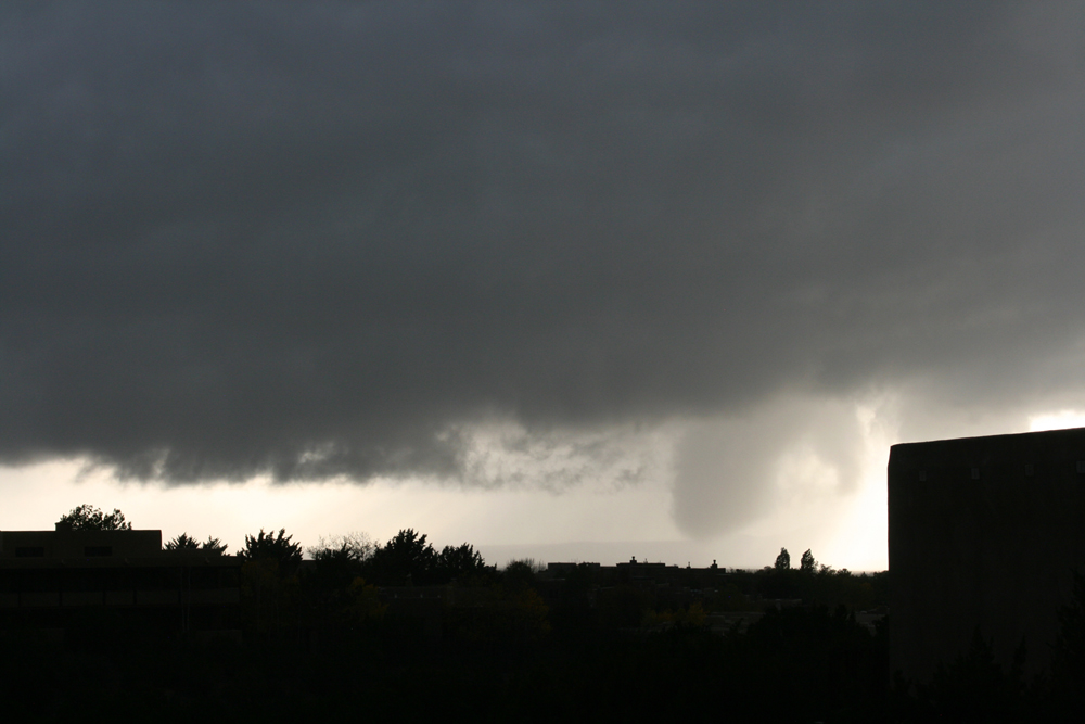
That storm likely came very close to producing a tornado northwest of Santa Fe around 5:30 p.m. And then in the evening, we had a near-miss with an EF-1 tornado that hit the city of Santa Fe while we were having a long-planned dinner with friends who were in town from Denver for a conference. With the many pictures, radar images, and a video that I have from this day, I have set up a separate web page for this day. You can view that here.
October 25 and beyond - On the last day of this storm activity in the Four Corners states, there were additional thunderstorms in both Santa Fe and Pagosa Springs, including a Pagosa Springs hailstorm that covered the ground with hail. However, in Santa Fe where I was at the time, no additional severe weather occurred. Driving back from Santa Fe to Pagosa on the 28th, we encountered one-lane traffic where flood damage to the road was being repaired near the intersection of US 84 and US 64 west of Chanma, NM. Also the effects of the flood were very evident along the Blanco and San Juan Rivers, although by this time the water had gone down.