
With CAPE reaching somewhere around 3000 j/kg and at least decent directional shear up and down the north-south dryline from NE down into TX, dynamics would be good across a large north-south swath. But due to capping and perhaps less than optimal timing of upper dynamics, some questions existed as to whether any storms would develop south of Nebraska. One area where some models suggested they might was south TX, southeast of the SE corner of New Mexico. Too far from where I was, and still uncertain. But models were pretty definitive on storms in Nebraska near the triple point, and the convection-allowing models (CAMS) were coming to a consensus that storms would also occur in far NW Kansas, moving into NE ahead of the dryline and east and SE of the triple point low, which would be near the intersection of NE, CO, and KS. I had this to say on Stormtrack the night before:
"Looking at the latest runs of the CAMs, they all initiate something in far NW Kansas or near the KS/NE state line, then move it northeast into NE. Specific locations and details vary, but they all seem to be picking up on that general idea. By around sunset it looks like the storms could cross north of the front (and thereby become elevated), but there seems to be pretty good agreement on the general idea of storms initiating in northwest KS or near the state line moving up into NE during the time period between about 21Z and 3Z. Given the environment, the storms are very likely to be supercells with potential for tornadoes and very large hail. I have prepositioned in Lamar, CO for tomorrow's chase, and unless things look a lot different in the morning, will probably head to northwest KS and expect to track the storms into NE."
By morning, the CAMs were even more bullish on Kansas storms, and as the Goodland NWS office put it, were in two camps. One favored the scenario I described above; the other favored more widespread storms ahead of the dryline in KS. What eventually happened was probably somewhere in between, with the expected scenario playing out in NW KS, another long-track tornadic supercell forming in the northern OK Panhandle and moving into southwest KS, and a third area of action in south Texas.
The chase:
It even had a miniature beavertail. This kind of structure was encouraging to me because of the kind of dynamics it suggested, yet a bit concerning because it was elevated, as was a more pronounced line of storms farther east. But with clearing to the west, I was hopeful that more surface-based convection would initiate, as forecast by all the CAMS.
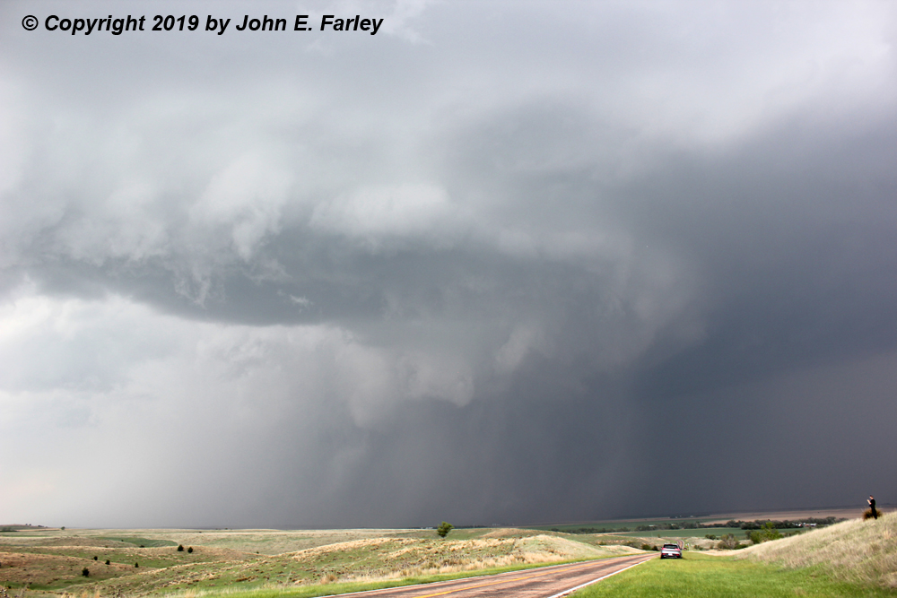
When I saw this feature, I was working north on 83 from Atwood to McCook via Oberlin. I decided to do this because the SPC mesoanalysis showed a more favorable environment for supercells and tornadoes in the area near and northeast of McCook. But by the time I got to McCook, I could see visually and on radar that storms had initiated SW of Atwood, so I went west to Culbertson and from there south on 17 back to Atwood. I first intercepted what would be the storm of the day a few miles west of Atwood, around 4:30 p.m. CDT, with lots of other chasers also watching.

At this point the storm was supercellular and soon went SVR-warned, mainly for large hail. It had a lot of rising scud and occasional lowerings, but did not appear that tornado was imminent at this time. However around 4:40 p.m. it did produce what appeared to be a brief, tiny funnel. But it dissipated quickly and went nowhere near the ground.

I watched the storm for quite some time from this position (in hindsight, probably a little too long). Eventually I knew I needed to stairstep east and north to re-intercept it. Going north form Atwood was not an option because the storm was about to cross that road with its large hail. So I went back to Oberlin and then back north toward Culbertson on route 17.
The first tornado reported from this storm was at 5:28, just on the Kansas side of the state line between Atwood and Culbertson. I did not see this one because I was repositioning and I was too far away and/or my view was blocked by rain. But I did get the next two tornadoes the storm produced!
By 4:35, I had caught up with the storm enough to see that it had an impressive meso, with a nice collar cloud rotating around a lowered area which definitely included a wall cloud, but at times seemed to produce funnels, too - now something with tornado potential.


The meso became somewhat wrapped in rain as it approached the highway perhaps 2 or 3 miles ahead of me, but you can see in this picture that a funnel appeared to be forming on the back side of the wall cloud. This was taken at 4:38, 2 minutes before what would be my first tornado of the day. Or maybe even it already was, as you can see what may be a narrow funnel extending down from the left edge of the wall cloud.

After this the meso got more rain-wrapped, but a tornado was imminent.
Tornado 1: 5:40 CDT, 8 miles S of Culbertson, EF-0
According to the Goodland, KS NWS, this tornado crossed Hwy. 17, which I was on, between mile markers 10 and 11. The pictures below, taken through some rain, were taken at that exact time. I was not sure at the time whether or not this was a tornado, but in the pictures it sure looks like one, and it was in the exact time and place where the NWS confirmed the second tornado of the day from this storm. Although very rain-wrapped, my first Nebraska tornado! No damage was seen by NWS or by me, but it was open country with not much to hit.

The first of the two pictures is enhanced a bit more, to make the tornado more visible through the rain. The tornado is the feature under the left side of the wall cloud. This tornado was brief, and soon all I could see was a rotating mass of clouds and rain, which crossed the road ahead of me. I then continued north toward Culbertson. I thought at this point I had pretty much lost the meso in the rain, so mainly wanted to catch back up with the storm. But I could see that an intense hail core, likely part of the hook, was about to move over Culbertson, where I had to go to get on 34 and go east. So I pulled onto a side road to wait that out. Lo and behold, three or four dramatic lowerings were right in front of me. I did not know at first what they were, but after a short time realized the left-most (northernmost) one was a tornado, as the funnel above lowered and eventually connected with the dust swirl rising below it.
Tornado 2, 5:55-6:01 CDT, 6 mile track from W of McCook (forming just S of route 34 and crossing it) to NNW of McCook, EF-2
My first picture of this, the McCook tornado, is at 5:55, just after it formed. I have pics and video of it through ropeout, though I messed up my video of the first few minutes of it. Here are the first two in a sequence of pictures showing the lifecourse of the McCook tornado from just after it developed through ropeout:


In these first two pictures, you can see both the tornado and a lowering just to its right that actually extends farther toward the ground than the condensation funnel itself. This definitely confused me at first, as particularly in the first picture, the dust swirl seems displaced from the feature extending closest to the ground from the cloud. But it turns out this feature was part of the collar cloud around the tornado, which was very pronounced and at times unusually low for this kind of feature. If you look closely at the first picture, you can see that the condensation funnel is there, in the place where you would expect it to be, but not extending as low to the ground as the collar cloud feature. The condensation funnel of the tornado is more separated from the collar cloud lowering in the second picture. The condensation and the dust swirl connected to form a beautiful tube, which continued for a few minutes until it began to rope out:


During the ropeout stage the condensation funnel became very narrow and horizontally stretched out, but the dust swirl actually became bigger. It was likely at some point during its ropeout that the tornado caused the most serious damage, hitting a farm and destroying a number of structures and severely damaging the farmhouse. Fortunately the couple who lived in the house knew well where the safest place in the house was, and went to the one room that remained fully intact, thus avoiding injury. Here are a couple video captures of the tornado in the ropeout stage:


One other interesting feature about this tornado was that several large areas of dust were lifted well to the south of the tornado - you can see that in several of my pictures, even though I was several miles from the tornado and looking at it through some rain. These were likely associated with an RFD gust front and/or rear inflow jet extending south from the tornado. In one chaser video I saw, one of the dust clouds well away from the tornado was rotating, so I suppose that feature would be classified as a gustnado.
After that, I crossed through Culbertson and stopped briefly to photograph hailstones. Biggest was a spiked stone at least 2.5" in diameter:

By now the meso had crossed route 83 north of McCook and moved into an area with a poor, curvy road network of largely unpaved roads. I did not want to risk getting stuck in the mud and/or getting caught in a hail core with no way to escape, so I took a longer route east on 34/6 and then north on 283 to eventually re-intercept the storm near Eustis. Some who ventured into the area with the poor road network were rewarded with a couple of rather spectacular tornadoes near Stockville, including the strongest tornado from this storm which was rated EF-3. But some of them were thwarted by the limitations of the road network, the traffic, and the rain-wrapping and got little or no view of these tornadoes and nothing thereafter. I missed these tornadoes and also the ones a little later near Farnham because I was too far away while repositioning and in any case my view was blocked by rain. By the time I got back on the storm just west of Eustis, a big dusty tornado was under way to the north, forming along I-80 just east of Cozad and tracking a little more than 10 miles to the northeast. I missed most of this tornado, but am pretty sure I did manage to get a distant glimpse and a little video of it.
Tornado 3, 7:54-8:10, 10.17 mile track from 1.5 miles E of Cozad to 11 miles NE of Cozad, EF-1
As noted above, I missed most of this tornado due to rain-wrapping, but did see and video what was likely a short portion of the tornado as it emerged from the rain around or after 8 p.m., perhaps toward the end of its lifecycle. What I have on video, though distant, resembles peoples' descriptions and closer pictures of the tornado. Here is a video capture:

The tornado numbers in the headers in this report refer to the number and order of tornadoes I saw/documented. As noted, there were a number of others I missed due to rain-wrapping and/or poor road network, especially N and NE of McCook. Overall, this storm was a very prolific tornado-producer, with a total of 13 tornadoes confirmed (as of the afternoon of May 20) in the Goodland, North Platte, and Hastings National Weather Service areas of responsibility.
Finally, in the evening, the storms had one last spectacular show to put on. After I called the chase, I headed to Lexington, NE, along I-80, to find lodging for the night. After finishing a celebratory steak dinner and chatting with chasers in the College of Dupage group as well as storm researchers from Texas Tech, I emerged from the restaurant to see this spectacular lightning display to my northwest:
By this time the storms had grown upscale into a large line, but had not moved a whole lot toward the east, and this linear MCS was where the lightning was occurring. A spectacular ending to a spectacular day!
Chase mileage for day: 490
Chase trip entire mileage: 1592