A line of thunderstorms, oriented from NNE to SSW and moving to the northeast or NNE, formed across the Pagosa Springs area around 10 a.m. At our house we experienced rain mixed with partially melted graupel or sleet, and thunder and lightning began. I had been hoping for a thundersnow chase at some point over the course of this three-day storm system, and it looked like now was the time. A quick radar check revealed the broken line of thunderstorms, with one cell over Pagosa Springs stretching a bit to the northeast toward Wolf Creek Pass, and another storm down the line southwest of Pagosa. So I grabbed my gear and headed out as quickly as I could, probably around 10:15 or a little later. Driving through town, I encountered a mix of rain and wet snow or graupel, but before long it turned to hail and came down quite heavily until I managed to get ahead of it in the downtown Pagosa area. From there up to the scenic overlook on the west side of Wolf Creek Pass, the line of storms was mostly to my northwest, having not really reached the area from Treasure Falls up to the scenic overlook with anything more than light precipitation. There was, however, a fairly heavy core of precipitation just to the northwest of the scenic overlook, passing by to its north or northwest.
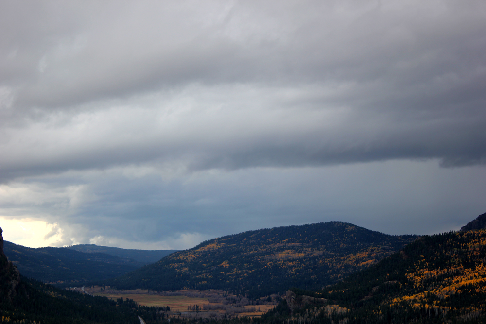
When I got to the scenic overlook, I got out and looked down the valley. The line of storms, oriented from the northeast to southwest, was over the mountains northwest of the scenic overlook, and in the distance down the valley to the SSE, I could see the cloud base under the main updraft of what was likely the storm that had been SW of Pagosa Springs when I left home. The line of storms had filled in to my northwest somewhat by this time. However, under the main updraft base down the valley, there were various lowered areas that might be characterized as a disorganized wall cloud. In this picture, you can see the larger structure of the line of storms and the updraft base:
Here is a more zoomed version, showing the main updraft base and the lowered areas under it:

There did seem to be some broad storm-scale rotation in this storm. The clouds closer to me were moving from left to right, while the ones farther away, including the lowered area, were moving from right to left. I did not make a whole lot of this until I found out that several hours later, on the other side of the San Juans in the San Luis Valley, a storm near Alamosa got two SVR warnings, both with a "tornado possible" tag. So I guess there was enough directional shear to get some storm-scale rotation. Since it was evident that the lowered area under the main updraft was going to eventually pass to my south or southeast, I was very confident that the storm would move over my location, and if there was thundersnow, I would be in a location to get it. There were soon rumbles of thunder out of the line of storms to my northwest, and I did see a flash or two of lightning just north of the lowered areas. I grabbed my camera and attached the lightning trigger, but was unsuccessful. Soon, as precipitation began to fall and lightning increased, I knew it was time to switch to video, which I did. At times, before there was very much precipitation, thunder coming out of the storm became nearly continuous. And after a while, graupel (snow pellets) began to fall, mixed with a little rain. For maybe 20-30 minutes, various mixtures of graupel, rain, and ordinary snow fell, irregularly becoming heavier, and with a lot of thunder. I figured once the heaviest core moved over me, it would pull down enough cold air to get all frozen precipitation, and that is pretty much what happened - as the precipitation got heavier, it went to all graupel (snow pellets), and then a mixture of graupel and ordinary snow. And with several visible flashes of lightning, followed by loud thunder. There were at least 3 flashes that were within a half mile to a mile away, but I think these were in the clouds or precipitation, not cloud-to-ground, given the long rolling thunder rather than a sudden boom. Eventually the precipitation became lighter, and the thunder and lightning much less frequent, so I decided to head up higher to see what I could see. By the time I made it to the summit of Wolf Creek Pass, there was a lot of heavy, wet snow on the ground, and a light, steady snow falling. But the sky was brighter, with no thunder, though some fresh snow and/or graupel had accumulated on the highway. So I pretty much knew that any thundersnow by then was past or northwest of the summit. I took a little video of the snow falling and of a snowman and people making another one, and decided to call it a day. Or so I thought.
I made two videos of this first thundersnow storm. One is a short one, about 2 minutes, taken during the heaviest precipitation and featuring two flashes of lightning followed by loud thunder. The other is a full edited video of this storm, better than 5 minutes long, beginning with the onset of precipitation and showing highlights of the storm and some short clips from Wolf Creek Pass.
Short video:
Full edited video:
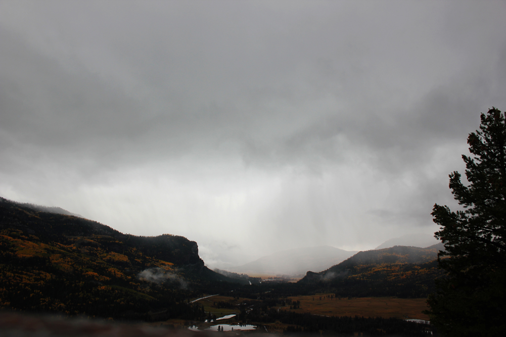
As I said, my plan at this point had been to head home, but as I got back down closer to the scenic overlook, it became evident that another storm was moving up the valley toward that location. So I stopped there again, got out, and snapped a picture of that storm coming up the valley:
Just after I took that picture, there was a flash of lightning followed quickly by a loud boom of thunder - this time it sounded like CG, and not far away. So I quickly got back in the car and switched to video. This would have been somewhere around 1 p.m. At first there was thunder and lightning but not much precipitation. Soon, however, just after some loud thunder there was a sudden burst of large graupel. Almost large enough to call hail, but the texture seemed to be that of graupel, not hail. And then, with continuing thunder and lightning, the pellets got smaller but fell more heavily, then mixed with ordinary snow. After a few more minutes the precipitation began to lighten and the sky looked brighter in the southwest, but dark in the southeast, so I decided to move uphill a bit to stay in the storm, stopping at a turnoff more or less across from the upper runaway truck ramp, a couple miles or so up 160 toward the pass from where I had been. Now, at this location, the precipitation type was entirely ordinary snow, and I was quickly rewarded with a flash of lightning quickly followed by loud thunder. 100% thundersnow now! I stayed there for ten or fifteen minutes capturing multiple instances of thunder. Eventually some graupel or granular snow did mix back in, but it was notably lighter and softer than it had been at the overlook. By around 1:30 I decided I really needed to get some lunch, so I called it quits and headed home after a long low rumble of thunder - my last of the day in the mountains, but I am sure far from the last one that happened in the area.
Again, I made a shorter and longer version of video for this storm. The short one, a little under 2 minutes and 45 seconds, presents the most intense thunder I encountered at each location. The second one is again a full, edited video just over 5 minutes long showing the full sequence of the storm.
Short video:
Full edited video:
As I headed down past Treasure Falls and back toward town, I was soon in sunshile with blue skies overhead. However, it also soon became evident that the day's weather still might not be over yet. To the northwest of Pagosa Springs there was yet another line of storms, with cumulonimbus tops that towered high into the northwestern sky. This cell would pass northwest of town, but it looked like other storms were going up farther down the line south/southwestward into New Mexico, still moving to the NNE. I could not tell for sure with the view I had, but a look at radar when I got home confirmed that there were some scattered strong storms well down the line into New Mexico. I had time to eat lunch before any of these storms arrived in Pagosa, but by around 3:00 one did. They began with some rain and what may have been either graupel or small hail, but quickly ramped up in to a heavy barrage of small hail that largely covered the ground and came off the roof into piles, also accumulating on neighboring vehicles and roofs. I got some phone video of this, first through the window and then from the garage. There was also one very close lightning strike, definitely less than 1/4 mile away, but I missed video of this because I had briefly switched to still photography. It was the first lightning with this cell, and had I known it was coming when it did, I of course would have stuck with video all the way. Here is a short clip of this storm:
Hail video:
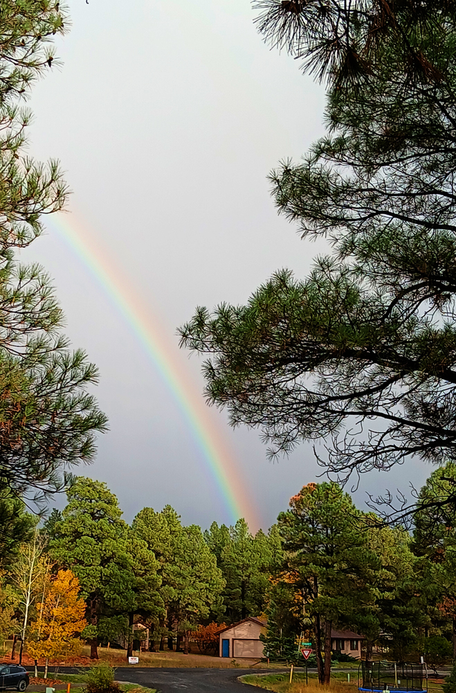
After this storm it rained and occasionally thundered for a couple more hours, and as this line moved up into the mountains, there was more snow and very likely more thundersnow. By this morning, a total of 26 inches had fallen at Wolf Creek Ski Area. With that settled to a well-compacted base of 18 inches, it is time for the ski season, and Wolf Creek announced that they will open for daily operations tomorrow, October 22. As the storms retreated from town into the mountains, their final gift was a rainbow, which I photographed from our driveway:
These storms were part of a very active weather pattern over southern Colorado and New Mexico associated with the aforementioned cutoff low. There were many severe thunderstorm warnings in both states, and some of them in both states verified with hail up to the size of golf balls, and in NM, wind in excess of 65 mph. And tragically, massive flash flooding around Roswell that took two lives and necessitated the rescue of around 300 people. There was a swath of 4-inch plus rain along I-25 just east of the Sangre de Cristo Mountains from Las Vegas, NM up through Raton, NM to near the Colorado state line. Many other areas across NM and southern CO experienced non-severe hail and 1 to 3 inches or more of rain. And, as noted, heavy snow accumulations in some of the higher mountains. Special weather statements were issued for both the second thundersnow storm I intercepted and the later storm that produced hail in Pagosa Springs, for hail, heavy bursts of snow, and gusty wind, although I did not experience any particularly strong wind.
Since this report includes both winter weather and a hail storm, I have linked it from both my 2024 Severe Weather Observation Page and my 2024-25 Winter Weather Observation Page
Return to 2024 Severe Weather Observation Page
Return to 2024-25 Winter Weather Observatiion Page