As the low pressure area tracked southeast, it eventually became cut off from the main northwesterly flow and began to move more slowly, more in a southerly and for a while even southwesterly direction. It also became more complex, with multiple circulation centers, and stalled over the southern California/northern Arizona region. With the cutoff low in this position, southwesterly flow became established over the Four Corners region. This type of flow is conducive to very heavy snow over the San Juan Mountains, especially with a cutoff low that does not move much so that the flow continues for an extended time. There are a couple reasons why this tends to produce very heavy snow in the San Juans. First, it is ideal for pumping a great deal of Pacific moisture into the region, and that is exactly what this storm did. Second, southwesterly flow maximizes the uplift as the wind flow encounters the southwest slopes of the San Juans, which are irregularly alligned from northwest to southeast. This combination of moisture and uplift can produce a great deal of snow in and near the San Juans, and that is exactly what this storm did.
An interesting feature of this storm is that because of its movement - first from NW to SE, then a drift to the SW and stalling - it was able to produce upslope flow and thus heavy snow both on the Front Range (first) and then later over the San Juans. This meant that areas both just east and just west of the Rockies were able to get a lot of snow, and that both the eastern mountain ranges such as the Colorado Sangre de Cristos and the foothills and mountains just west of Denver and also the western mountain ranges such as the San Juans were able to get a lot of snow from the same storm. More often, it is one or the other. This time it was both.
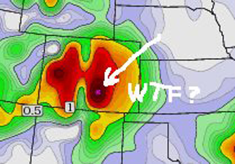
Despite its somewhat unusual movement, this storm was well analyzed and forecast by the weather prediction models. For example, consider this forecast map from the GFS model on February 17, four days before the first major impacts of the storm:
This map, provided courtesy of Matt Sellers via his Facebook page (with his editorial comment, lol), picks up well on the idea of very heavy snow in both the eastern and western mountains, as well as the Front Range cities just east of the mountains.
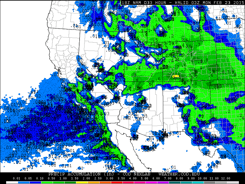
As the date got closer, the models increasingly began to focus on the San Juan Mountains and nearby areas as the bull's eye for very heavy snow. Here is a 33-hour precipitation forecast map from the NAM model from 18z on Feb 21 (noon mountain time on February 21) for snowfall through 9 p.m. mountain time February 22:
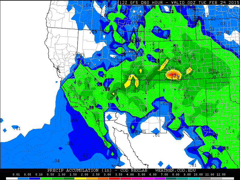
The GFS model from earlier that morning, extending further to 6 p.m. on February 23, showed even heavier precipitation amounts, but again centered on the San Juans:
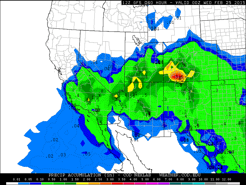
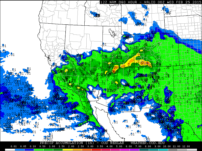
By the next morning, as the storm was starting to get under way in southwest Colorado, the models were predicting even heavier and more widespread snowfall, but continuing with the bull's eye for the heaviest snow over the San Juans. (Although by now the models, particularly the NAM, - correctly, as it turns out - were also predicting some very heavy snowfall over parts of southern Utah and northern Arizona.):
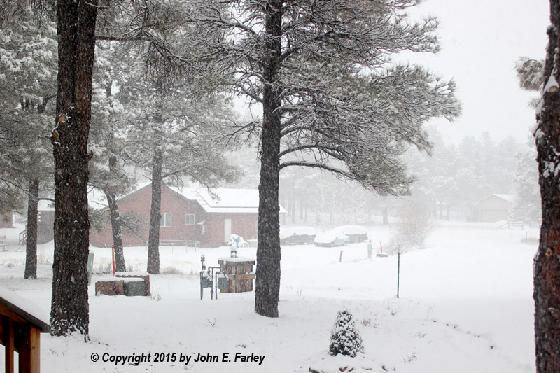
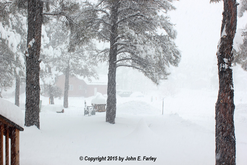
Snow began to fall at my home in Pagosa Springs, CO very early the morning of Saturday, February 22. By around 9 a.m., 2 inches had fallen, and a steady snow continued through most of the morning; indeed through most of the day. When this picture was taken around noon, we had received 4.7 inches of snow:
Except in a few places where it had been piled up, there was no snow on the ground when this storm began, as we had experienced a long period of warm, dry weather. So all of the snow on the ground is from this storm. Moderate to heavy snow continued through most of the rest of the day, and after an evening lull, resumed again later that night. By 4 p.m. the snow total was up to 7.7 inches, and by 10 p.m., 8.9 inches. Another 7.1 inches fell overnight, bring the storm total to 16 inches by 8:30 a.m. on Sunday, February 23. The next two pictures were taken around 11 a.m. and noon on February 23:
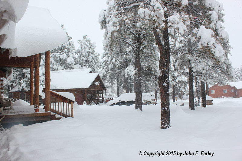
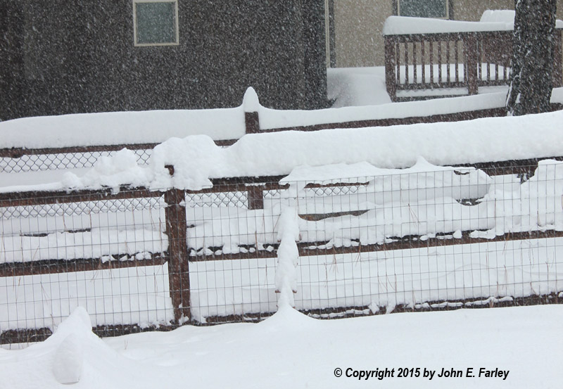
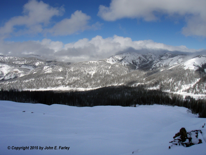
Note in the picture above, the snow is halfway up the 3-foot snow stake in our back yard (the vertical thing mostly covered by snow to the right of the fencepost). By now, the snow had become more intermittent and showery, but sometimes still quite heavy. An especially heavy burst came around 2:30 p.m., not long before the snow stopped and the sun came out:
This picture was taken from the same place as the first photo above; note how much more snow there is now and how the small tree in the foreground of first picture is now completely buried.
At this point, our storm total was 19.2 inches. The center of the low pressure was now drifting southeast from northern Arizona toward New Mexico. By the February 24th, most of the snow from this system was falling in Arizona and New Mexico, but a few snow showers rotating around the northern fringe of the storm the evenings of the 23rd and 24th brought our final storm total to 19.4 inches. This is the most snow I have seen from a storm in a city or town rather than at a ski area since December 28-30, 2006 when a storm dumped 24 inches on Santa Fe, New Mexico. And that may be the only storm I have ever experienced other than at a ski area that produced more than this one, although I did experience a couple in Michigan in the 1970s that came very close to 19 inches.
Speaking of ski areas, this storm produced some very impressive snow totals at ski areas and other mountain locations in the San Juans, with 40.8 inches at a snow telemetry site in Mineral County north of Pagosa Springs, and 31 inches at the Purgatory/Durango Mountain ski resort. The heaviest amount measured was 42 inches at the Wolf Creek ski area northeast of Pagosa Springs. The following links are to public information statements from the Grand Junction and Pueblo, CO National Weather Service offices showing how much snow fell at various locations in western and southern Colorado:
Snowfall reports from the Grand Junction NWS Office
Snowfall reports from the Pueblo NWS Office
Although the Pueblo office lists the total for Wolf Creek Ski Area as 39 inches, it was still snowing when that report was made late the afternoon of February 23, and by the morning of February 24, the total had reached 42 inches. I was fortunate on the 24th to be able to ski at Wolf Creek (once Wolf Creek Pass re-opened after avalanche control), and the conditions were great! Here are a couple pictures:
This is looking northwest from the top of the Bonanza chairlift. The snowfield in the foreground is an out-of-bounds area known as the "rock garden," and normally its appearance lives up to its name. But after three and a half feet of snow, most of the rocks are now hidden. This one storm nearly doubled the snowpack in this part of the San Juans.
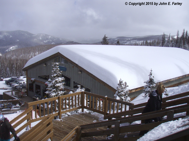
This picture of the rental and ski shop building shows how much snow piled up on top of the building.
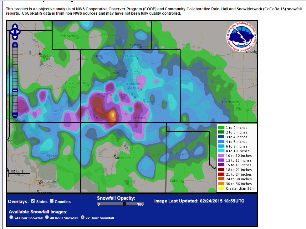
The following map from the National Weather Service shows total snowfall for the 72-hour period ending at 7 a.m. on February 24. It does not quite capture the entire storm, since some snow fell in northern Colorado before this period and some in Arizona and New Mexico after. But you get the idea. And note that the model forecast bull's eye over the San Juans verified very well! The yellow "greater than 36 inches" area is pretty much centered on Wolf Creek!
Return to 2014-15 Winter Weather Observation page