
These storms also had major impacts in parts of Arizona, Nevada, New Mexico, and Utah. The February 13-14 storm produced mostly rain in New Mexico, except in the highest elevations, where up to a foot of snow fell. There was even a rare freezing rain event in a portion of the Santa Fe ski area between 10,300 and 11,300 feet, with heavy icing from this storm still evident several days later when I was skiing there. In this picture, you can see the ice, which on a few trees was as thick as 3/4 inch, on an aspen tree:
This not rime, which is common at this elevation, but rather hard ice caused by an accumulation of freezing rain, which is very unusual at this altitude. Ususally if the temperature is below or even near freezing the precipitation type at this altitude will be snow, but this was an unusually warm storm and there was a warm layer quite high up - high enough to melt the falling snow to rain above this point, where it fell into a layer of air that was below freezing, causing the rain to freeze on contact to the trees.
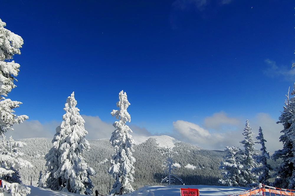
The next storm brought a foot of light, fluffy powder to Ski Santa Fe, and the combination of rime (from being in the clouds at subfreezing temperatures) and snow on the trees made for a spectacular sight. Here are a couple pictures taken at the top of the ski area, elevation 12,000 feet:

This storm also produced the rare event of a tornado associated with a snow squall, near Tinian, NM to the northwest of Albuquerque on the Navajo Reservation. This is not a snow devil but a true tornado, i.e. a column of spinning air connecting the cloud to the ground. Although tornadoes associated with snow squalls do occasionally happen, they are rarely photographed because they are usually wrapped up in snow and difficult or impossible to see. But this one was very visible as it lofted snow into the sky. Here is some video taken by a local rancher:
Farther west, massive amounts of snow fell from the February series of storms in California's Sierra Nevada. A February record was set halfway into the month at the Mammoth ski resort, and by February 22, a total of 198 inches of snow had fallen at the Main Lodge - that's sixteen and a half FEET of snow in just 22 days. Of that total, 91 inches fell in the AR event the first week of February, but the next three storms brought another 107 inches from February 9 through 22 - nearly 9 feet of snow in two weeks. The snow also piled up very deep in the Lake Tahoe area. Here is a picture my cousin sent me of the snow at his ski house in Tahoe City, CA, located just above the level of Lake Tahoe:

The third storm in the mid-February series of storms brought rare snow to a variety of normally-warm places including Las Vegas, NE and Hollywood, the Rose Bowl, and the suburbs of San Diego in California. Officially, just under an inch fell in Las Vegas, and at least trace snowfall was reported there on five days in February - an extreme rarity.
Some of the biggest snow totals from this storm were in Arizona. A foot and a half fell in Kingman, and in Flagstaff, over 40 inches fell. Nearby Munds Park got 43 inches, and Prescott received over two feet (27-28 inches). This storm also brought the second-largest single-storm snow total of the winter to our house in Pagosa Springs, CO, 16.3 inches. Here are a few pictures:

In the picture above, taken late in this storm, you can see the cumulative effect of the series of storms. More than 3 feet of snow on the ground - enough to make our 3-foot snowstake disappear! You can see that in the following sequence of pictures, taken on the 20th, 21st, and 22nd - in the first one, the top of the stake, showing the number 3 (for 3 feet) is visible to the right of the fence post - then in the next two pictures, it disappears and is totally buried. Going, going, gone!

This picture was taken during the storm's final heavy burst of snow Friday afternoon, which reached or exceeded a two-inch-per-hour snowfall rate:

This storm also brought some big snow totals in the mountains of New Mexico, where accumulations ranged up to 35 inches at Ski Santa Fe and 22 inches at the Sipapu Ski Area. Parts of the Albuquerque and Santa Fe metropolitan areas received 4-7 inches, with an official total of 3.6 inches at the Albuquerque Sunport - a record snowfall and record precipitation for February 22.
The influence of this third storm extended well beyond the west and southwest. After moving on from these regions, the storm became a blizzard on the Great Plains and in the Midwest, and triggered tornadoes in the South and Mid-South. Omaha experienced blizzard conditions, with 2-inch an hour snow, accompanied by thunder and lightning and wind gusts to 47 mph. Multiple tornadoes occurred in Mississippi, Tennesee, and Alabama, including an EF-3 that hit the city of Columbus, MS, unfortunately resulting in one fatality and eleven injuries. Flash flooding was also a problem in many areas, including the cities of Nashville and Knoxville in Tennessee.