
The truth is I had not paid much attention to weather most of this day, because I was just too darned busy. I knew a strong system was moving through the area, and that 1) there was chase potential on the plains of northeastern NM and eastern CO, and 2) strong storms with gusty wind and hail could also occur closer to home in southwestern CO and northwestern NM. But that was the extent of it, as I was scrambling to get a lot of things done that had to be done in a short time frame. But finally by mid-afternoon, I felt caught up enough to turn my attention to weather. I had noticed a strong storm on radar initially somewhere near or a little south of Farmington, NM. What caught my attention was that this storm was the first one I had ever seen in that area returning strong echos on both the Albuquerque and Grand Junction radars. Northwest NM and southwest CO are a long way from both radars, and mountains also interfere to some degree, so it is not unusual in Pagosa Springs, for example, to get heavy rain or snow with little or no visible radar return. As I finished the last of my urgent tasks, I checked the radar occasionally and saw that the storm was holding together and looked pretty discrete. Around 3:30, I decided to head out, feeling pretty confident that the rather slow movement of the storm to the ENE would allow me to intercept it somewhere near Chromo, CO or Dulce, NM via U.S. 84 from Pagosa Springs.
In Pagosa Springs, we had had intermittent showers and thunderstorms for three days, beginning Friday afternoon, with the heaviest rain of the entire monsoon season and at times some small hail. The repeated storms had brought the temperature down from the mid-70s when the storms began Friday afternoon to the mid-40s now, as Pagosa continued to be in the steady, cold light rain from the stratoform portion of the storms to our southwest. As I drove through downtown Pagosa Springs to acess U.S. 84 south, my car thermometer registered 42 degrees as the rain poured down amid occasional long but loud rolls of thunder from in-cloud lightning overhead. Where I could see the mountains, they were very covered in snow. In fact, it looked like there was snow down to about 8,500 or 9,000 feet. Heading southeast toward Chromo, as I cleared the rain, I stopped to get a few pictures of the snow-covered mountains, with aspens displaying their fall color in the foreground:
I could occasionally get an internet connection on my phone (not something you can count on in rural SW CO or NW NM), and could see that the storm was maintaining its intensity and continuing to track to the ENE toward Dulce. And now, unlike when I left home, it had a SVR warning on it. One problem with chasing in this part of the country is that in most places, mountains and/or mesas are blocking your view of the horizon. Hence, it was impossible at this time to get any visual clues as to what the storm was doing. However, based on the radar, the discrete nature of the storm, the fact that it was the tail-end storm, and its persistent intensity, I became more and more convinced that the storm was likely a supercell. It was also moving slightly to the right of most of the storms, i.e. to the ENE when most of the storms were moving to the NE. This is also characteristic of supercells that have a high potential for severe weather. When I got to Chromo, CO, I decided to head a little southwest along the road that parallels the Navajo River. I did not want to go too far, becasue 1) it was an unpaved road, not in great shape after all the rain, and 2) I wanted to be able to backtrack to U.S. 84 and head southeast to where it intersects with U.S. 64 between Chama and Dulce, NM to intercept the storm. But I was still well ahead of the storm, and the Navajo River Canyon offers a decent, if narrow, view to the southwest where you can actually see a little of the horizon between the mesas, and the updraft area of the storm would move right across that view as it approached Dulce, NM.
Looking down the canyon, I could see the updraft base, along with an occasional lowered area, moving right to left across the canyon, teling me that the storm was continuing to move on a track that would take it to the south of my present location, somewhere near or a little north of the intersection of U.S. 84 and U.S. 64. I figured I would watch it for a while, then head down to that intersection and go where I needed to in order to let the storm pass just a little to my north. As it turns out, I underestimated the effect of the delay in the radar image I was seeing and waited just a little too long for that strategy to work, but it would turn out all right. Gradually the precipitation filled in the space under the clouds down the canyon to my southwest, the thunder got louder, and I began to hear a roar - not sure how much of that was the wind hitting the trees versus hail roar; probably some of both. But soon I knew it was time to hightail it back to U.S. 84 and get south. As I got near 84, I saw the interesting sight of the shelf cloud along the leading edge of the forward flank precipitation running right into the San Juan Mountains to my north or NNE:

The storm was very close to me now, and as I headed down 84, a bit of hail began to fall. As I went southeast ahead of the storm approaching from my SW, a little hail gradually turned into a lot, and the size increased. Most of the hail was dime to penny size or smaller, but there were a few larger ones starting to mix in, up to at least quarter size (1 inch). As I headed southeast, more or less along the leading edge of the front flank precipitation, I again got just ahead of the precipitation and stopped again to get a picture of the storm's impressive, low updraft base, illuminated by the low angle of the sun to the west:

When I took this picture, from perhaps 2 miles north of the intersection of 84 and 64, I had no idea how exciting things were about to get. If you look closely at the clouds above the left edge of the mesa down the road, you can see the leading edge of a lowered area starting to emerge from behind the mesa. I had no idea at the time, but I now think that was the leading edge of the lowering associated with the tornado I was about to see. After taking the picture, as the hail started to catch up to me again, I headed down the road. When I got about to where the road crests the high spot in the picture above, I suddenly saw a cloud tag under the updraft base racing east at an extremely high rate. I knew something was up, and pulled over and grabbed the video camera. Almost as soon as I began to video, it became apparent that the clouds were rotating extremely rapidly and quite near the ground, at least in the higher places, and that a tornado could be in progress. So I jumped out of the car and stood in the hail, and got about a minute of video of the cloud tags spinning low and fast, with a brief condensation funnel down to the ground (at least what I could see of the ground in the hilly terrain) on the right (west) side of the area that was rotating. I was almost certain that I was witnessing a tornado! Since its movement to the ENE could take it very near Chama, NM, I knew that it was urgent to call it in to the NWS. But that is no easy task in northern NM, where cell signals are very spotty. My initial attempts to call failed, but as I inched along in the once-again heavy hail, I got enough of a signal to reach the Albuquerque NWS and tell them I had just seen what I thought was a tornado a little north of the split of U.S. 84 and 64. Shortly later, I reached where the damage path crossed 84, and called again to tell them of the damage and that it definitely was a tornado. Here is a video capture of the tornado:

My video of the tornado can be seen on Youtube here.
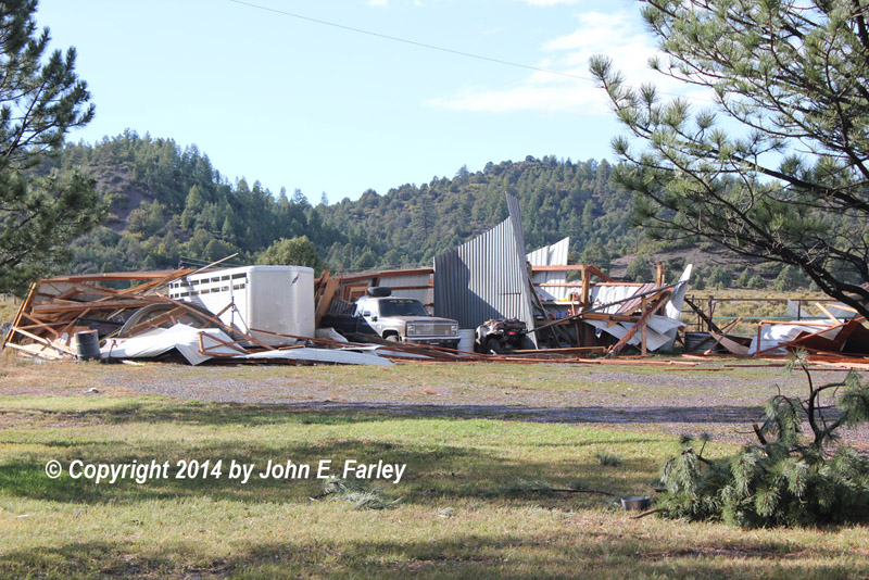
Where the tornado crossed 84 there was a wire of some kind down across the road. I stopped the next car behind me from driving over it, but then a car coming the other way crossed it with no problem, so both I and the car behind me continued on. Just a little farther I noticed ranch buildings badly damaged a short distance to the west of the road, so I went to one of the two houses there and knocked on the door to see if anyone who may have been there was OK. There was a machine shed that was destroyed, with most of it down on top of a pickup truck and a horse trailer. One of the two houses (which turns out to have been the ranch's bunkhouse) had what appeared to be relatively minor roof damage, but the other one (which was the main residence) had lost its entire roof, much of which ended up on or near the highway. At first nobody answered my knock, but after a minute or so a rather shocked-looking gentleman emerged from between the two houses. I asked him if everyone there was all right, and he said, "Yes, but we are lucky to be alive." It turns out that he (the owner of the ranch) and one of his employees had been working in the shed that was destroyed when the tornado hit and the shed began to come down around them. They ran out of it in the nick of time, and somehow avoided getting hit by any of the flying debris. (Fortunately, the house that had the more severe damage was just apparently downwind from where they were.) I told him they had been hit by a tornado, and he said that was what they had figured it was. I asked him if they had taken shelter in one of the houses and he said no, there was not time. He was very grateful to me for checking to see if they were all right, and although I offered him my cell phone to use, he said he had one and would go to a nearby spot with a better signal shortly to make some calls. He gave me permission to take a few pictures of the damage. A picture of the destroyed shed can be seen here, and a picture of the house that lost its entire roof can be seen here.
I called the NWS in Albuquerque a third time, to let them know about the damage to the buildings. Back out at the road, I noticed that part of the roof was still blocking the northbound lanes of 84, so I pulled the debris off the highway. Nasty stuff, full of nails that would easily take out a tire. Much more of the roof was piled up just off the west side of the road; not sure if that is where it landed or whether it was pulled off by someone who was there sooner than I was.
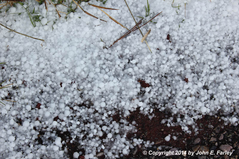
At this point, the storm was long gone, so I started back to Pagosa Springs. Although it was now a half hour after the storm had passed, there was still a lot of hail where the main precipitation core of the storm had crossed 84 a couple miles south of the state line. As I got closer to Pagosa Springs and the sky cleared more, the view was more reminiscent of early winter than of what you would expect to see an hour after seeing a tornado:

In fact there was so much snow (or more likely a mix of snow, graupel, and hail) in the mountains that the chain law was in effect for Wolf Creek Pass, and eventually the pass was closed because of a jackknifed semi. Some of the snow was from storms earlier in the day or the night before, as there was already some when I was heading out for the chase, as documented in the early picture. (In fact, I later learned that a severe storm a few hours earlier had passed just southeast of Pagosa Springs, producing golfball hail and blowing down many trees about 4 miles east of town. Undoubtedly this storm, too, produced copious amounts of snow, graupel, and hail in the nountains.) But it is very likely that more snow fell in the mountains from the storm that produced the tornado, as it moved right up into the higher mountains not long after producing the tornado. Strangely, this is the second time this year that I have seen one or more tornadoes in areas within sight of snow-capped mountains. The other was June 6 near Trindiad, CO.
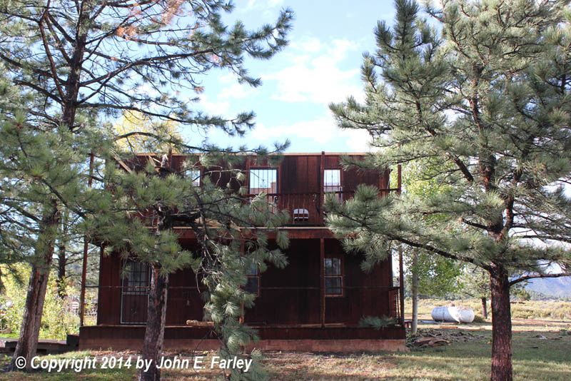
The next day, I drove through the area where the tornado occurred en route from Pagosa Springs to Santa Fe. I checked my odometer to see the distance between where I had watched the tornado and where it crossed the road, which turns out to be about 1.3 miles. I also saw then that another building I had not noticed the previous day had been totally destroyed by the tornado. This building was at the top of a hill to the west of the ranch. According to some people who have commented on my Youtube video page and the NWS damage survey, discussed below, this building appears to have been a small church or chapel. My feelings go out to all who were impacted by this tornado - the rancher, his family, and his employee who shared his narrow escape, all who worshippped at the chapel, and anyone else who may have suffered adverse impacts. As awe-inspiring as storms like this one are to see, it is sobering to see how they can turn people's lives upside down in a matter of a minute or two. I also headed a little west on 64 from where the two highways split to see if I could see how far west the tornado began. The damage path starts at least one mile west of the intersection of the two highways, as I could see a lot of trees broken off in the distance to the north of route 64. This was a very unusual event for this part of the country. There were just two tornado reports this day, this one and one in western CO - both of them west of the Continental Divide (mine only by about 3 miles, though). Very unusual! This was my first New Mexico tornado, my first tornado west of the Continental Divide, and my first September tornado. It was also quite amazing that the highest temperature I saw on my car thermomenter up to the time of the tornado was 48 degrees F, and the elevation where the tornado occurred is around 8,000 feet. I suspect there was some warmer inflow on the south side of the storm, but certainly not the kinds of temperatures and dewpoints we usually associate with tornadoes. But the upper air was very cold, so I am sure the lapse rates were pretty good, and certainly there was wind shear. But not the location, elevation, or temperature we usually associate with tornadoes for sure!
On Wednesday, October 1, personnel from the National Weather Service in Albuquerque conducted a damage survey in the area. The tornado was rated high-end EF-1 with a damage path 2.3 miles long and 0.4 miles wide at its widest point. The tornado occurred near the end of a longer wind and hail damage swath that stretched for at least 30 miles, including Dulce where golfball-sized hail fell. You can read the full damage survey here.
Although the only two tornadoes occurred west of the Divide, this day's storms had fairly substantial impacts in various places in NM and CO. Both Albuquerque and Denver had significant severe weather. In Albuquerque, an microburst destroyed a large tent that was being set up for the Rio Grande Art Festival, and in Denver heavy accumulations of up to golfball-sized hail caused considerable damage.
A summary of Local Storm Reports in the Albuquerque CWA can be seen here. Total chase distance: only about 83.5 miles.
Return to 2014 Severe Weather Observation Page