
I didn't see the tornado, but I did start the day with photography of the snow in the mountains and then in the afternoon intercepted a strong storm near Chimney Rock and then tracked it back through the Pagosa Springs area as it produced a 50 mph gust and a wide variety of precipitation. I'll start this report with a picture of the snow in the high mountains southeast of Pagosa Springs:
This snow fell overnight the previous night, in the highest elevations of the San Juan Mountains southeast of Pagosa Springs, between Wolf Creek Pass and Chama, NM. The snow became visible in the mid-day sun as the clouds cleared enough to reveal the mountains. You can also see some of the fall foliage from the aspens in the middle elevations of the mountains, although this shows up better in some of the pictures below after the afternoon storm.
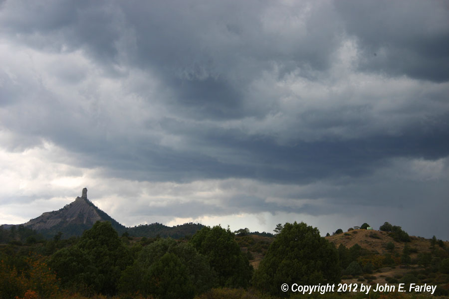
Around 2:30 p.m., I was heading out for more pictures when I noticed a strong storm off to the west, approaching Chimney Rock. (Note: Chimney Rock, a place of both geological and archeological significance about 20 miles southwest of Pagosa Springs, was designated last week by President Obama as America's newest National Monument. It also turns out to be a good place for weather photography, when the storm is in just the right place.) I decided to head west on U.S. 160 toward Chimney Rock to intercept the storm. As I got within five or six miles of Chimney Rock, the storm was looking good:

Chimney Rock is the geological feature just left of center in the picture. It is partially obscuring some scuddy lowerings under the storm's updraft. Those show up a little better, just to the right of Chimney Rock, in this picture, taken a few minutes later from a location closer to Chimney Rock. There are also a couple lowerings under the cloud base closer to the precipitation core. I was too far away to tell whether there was any rotation in any of these lowerings, but if there was, it did not persist for long, as after this, the storm became more outflow dominant. There was some directional shear, with strong inflow from the south as the storm moved around 30 mph to the ENE. Enough shear, in fact, for a tornado around ten minutes earlier on another storm farther up the line near Del Norte, about 70 miles northeast of this location in the San Luis Valley. That tornado, which has not yet appeared yet in the local storm reports, was likely a landspout - a Denver TV station confirmed that it was a tornado by showing video of the long, thin, and largely horizontal funnel and an associated dust swirl on the ground, although the condensation did not extend to the ground. Nothing that interesting with my storm, but mine still did offer some nice photo ops.
When I reached the turnoff to the south from route 160 for Chimney Rock, the core of the storm was crossing route 160 a few miles to the west. I thought about heading into the core to see what mix of precipitation was falling, but decided instead to see what photo ops I could get at Chimney Rock with the storm in the background. I'm glad I chose this option, because although the storm was now rapidly becoming more outflow-dominant, the photo ops were good. Here is a panorama stitch of four photos, showing Chimney Rock in the foreground and the storm in the background:

At the time I took this, I was still in the inflow, with wind blowing at what I would estimate to be 25-30 mph from the south. As the storm was now getting ahead of me, I decided to head back northeast toward Pagosa Springs on route 160, and was soon in gusty northwest winds. Around this time, the storm produced a 50 mph gust at the Pagosa Springs airport on the northwest edge of town. I decided to head north on Pagosa Blvd, the only real north option as roads are limited by the mountains and one is closed due to construction, hoping to sample the core. However, the storm was moving too fast, and all the precipitation I was able to get into was from the stratiform region. As I headed north, the roads were covered with pine needles blown off in the wind swath that had gone through the airport a few minutes earlier. As I got into the stratiform region of the storm, I encountered a mix of rain and half-melted graupel and/or snow, as several CG bolts zapped down within a mile. Thus, my favorite oddball precipitation type - "thunderslush!" I only recall seeing this once or twice in all the decades I lived in the Midwest, but in the higher elevations of Colorado and New Mexico it occurs fairly often, especially in the spring and fall.
As the precipitation lightened, I could see that I was behind the storm and would have no chance of catching up, and noticed new storms off to the southwest somewhere near Chimney Rock again. I headed back down to route 160 and turned west, but didn't go far since by the time I could see Chimney Rock again I could also see that the storms were passing south of there, and I would have no chance to itercept them heading that way. So I turned back, and I am glad I did, because by then the initial storm had cleared the high mountains north and northeast of Pagosa Springs, revealing this combination of mammatus, fresh snow on the highest peaks, and fall foliage in the middle levels:

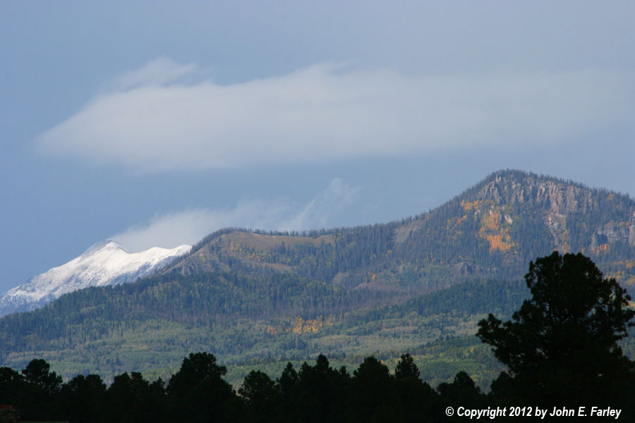
I noticed that the clearing and sun were gradually working east toward other high mountains, and figured that as this happened there would be more photo ops. As the clearing continued, I headed to the south shore of Pinon Lake on the west side of Pagosa Springs where there is a nice view northward toward the mountains. Once there, I was treated to this:

The snow (or perhaps more accurately, some indeterminate mix of snow, graupel, and/or hail) in the high mountains here was from the storm that had just passed over, as there was none in this area earlier. Farther north in the high mountains, the accumulation appeared to be deeper. Since in the latter area the mountains had been obscured by precipitation much of the day, it is possible that the greater accumulation may have been from a combination of the most recent storm, earlier storms (including possibly the one that produced the tornado on the other side of the mountains near Del Norte), and the numerous showers that occurred the previous night. Hard to tell, since this was the first time all day that you could see the mountains farther north.
By this time, the storms were coalescing into a solid NE-SW line, positioned slightly south of Pagosa Springs and moving east. They seemed to be intensifying again, and CG lightning was now occuring to the south. I started south to try for a new intercept, but it soon became clear that at best, I would have to go quite some distance south to catch back up to them. So I called it a day, and it was a pretty good one for maybe 75 miles of total driving.
Return to 2012 Severe Weather Observation page