
After overnighting in Trinidad, I headed out mid-morning with a preliminary target of somewhere around Springfield, CO. This day was a classic setup for Colorado severe weather, with a stalled cold front up against the Front Range with moist southerly/SSE flow east of it and strong westerly upper winds - about 90 degrees of directional shear and decent speed shear, too. CAPE was projected to be unusually high for Colorado along the southern part of the Kansas state line, over 3,000. You can get big storms in CO with far less CAPE than that, so I figured that with this combination of instability and shear, another day of supercells was a pretty sure bet. For what it is worth, it also felt very sticky and muggy in the morning in Trinidad - unusually so for this part of the country. I targeted well east, in the area east of Kim into Springfield, because of the highest instability there, figuring that if storms fired over the mountains and came out onto the plains, I could go back toward them and at least they would be moving toward me.
The chase:
As I got near Kim, I could see that there were some storms over the mountains and some towering cumulus also visible to my east, probably in KS. There is no mobile internet data in this part of CO except, with varying reliability, near the towns, which are few and far between. I continued on to Springfield, partly because I wanted to be in reach of the storms to the east if they really got going, partly because there was no lunch option and only slow data in Kim. Got lunch and data in Springfield around 12:30. I could see that the KS storms were still skimpy, but one intense isolated storm was just west of Trinidad. By 12:45, this storm had its first SVR warning. Also, a severe thunderstorm watch was issued for eastern CO at 12:40, for which my phone alarmed. I was a little surprised it wasn't a tornado watch, but it did still mention the possiblity of a tornado or two.
Looking at the SPC Mesoanalysis Web pages, I noticed right away that high CAPE extended farther west than morning models had predicted - essentially it was 2500-3000 from the KS state line west to the mountains across southern CO. Visually, it did not look like anything was about to develop any time soon between the big storm near Trinidad and the weaker, scattered ones forming in western KS. All this said get back west and try to intercept the Trinidad storm, which is what I did, around 1:00 p.m. I figured that, with my westward movement and the storm's motion to the east, I could be on the storm by around 2:30.
Despite limited data, I noticed a tornado report on GRL3.2 (like that feature!) around 2:00 or so just east of Trinidad. Soon I could make out a dark area extending from the cloud to the ground, to the left of the main precip area of the storm. At that distance (over 40 miles) I wasn't sure if it was a big, dusty tornado or an intense precipitation shaft, but gradually it became evident that it was a big dusty tornado, and in the same place roughly as where tornadoes were being reported.
My observations of the tornadic phase of the storm, with times:
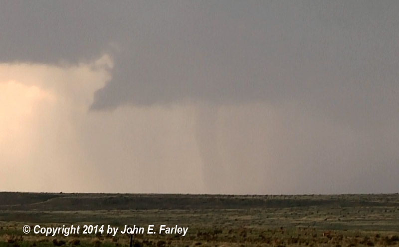
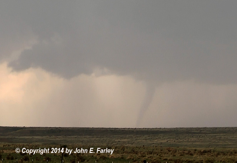
2:15-2:25 (approximately): I watched the first tornado, a big dusty one, starting from more than 40 miles away, but working my way closer. Despite its being so far away, there was enough contrast that I could get decent pictures of it with my 70-300 mm lens. It gradually became more visually evident that what I was looking at was indeed a large dusty tornado, with dust being blown around a large area around the condensation funnel. The tornado gradually narrowed as it began to rope out after I had been watching it for 10-15 minutes and working my way closer to it, but the dust was still being blown around a pretty big area. During the latter part of this first tornado, a new wall cloud formed to the left (S or SE) of the tornado, indicating that the storm was cycling.
A picture of the tornado a few minutes after I first saw it:
The next picture shows the tornado entering the ropeout phase, with lots of dust blowing around, and the new wall cloud forming to the left of the tornado as the storm cycled:

Soon, a pronounced RFD cut came around the new wall cloud, and a bowl-shaped lowered area appeared on the bottom of the now-rotating wall cloud. It looked like another tornado was imminent.
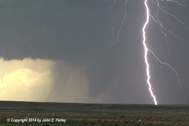
2:32: A tornado with thin funnel formed, visible about a minute:

This formed under the new wall cloud, to the left of where the earlier tornado ended. The funnel was not fully condensed to the ground, but I could see what appeared to be dust rising under the funnel, so I was quite sure it was a tornado. Other chasers closer to it have confirmed that it was.
What is less certain is whether this tornado was separate from the larger one that followed, or the beginning of it. It appeared to me that this tornado totally dissipated before the next one formed about five minutes later, but there seemed at first to be some disagreement on this point among chasers closer to it than I was. However, it appears from subsequent discussions that most who observed the tornadoes now seem to agree that it was separate.
A short Youtube video of the second tornado can be seen here.
2:37: A large tornado is under way. This tornado is big but not fully condensed at this time, but it is clearly a tornado. There is much less dust than with the first one, as this tornado formed in a area where heavy rain had fallen from one of the previous day's supercells. (The first tornado had been in an area where little rain had fallen, so was much more dusty.) Here is a video capture of the tornado not long after it formed:

In the early stages of the tornado, there was a little rain between my location and the tornado. I was closer to this tornado than the first one, but still probably somewhere around 20-25 miles away. There was occasional CG lightning occurring in the rain, and when I reviewed my video I was able to get a great video capure of lightning with the tornado, which by now was gradually becoming more rain-wrapped, but was still clearly visible:
2:45: The tornado becomes mostly hidden by rain for a couple minutes. Then it re-appeared, narrower and fully condensed to the ground. It looked like it was about to rope out, but it took a long time to actually do so, remaining fully condensed. I was looking at it through rain, but could see and video it.
2:52: The tornado roped out and disappeared. The duration of this tornado was about 14 minutes. That is, if, as I am fairly sure now, the second large tornado was separate from the one with the thin funnel. If these two were actually one tornado, then the duration was around 20 minutes.
A four-and-a-half minute Youtube video showing the highlights of the third tornado (the second large one) can be seen here.
The rest of the chase:
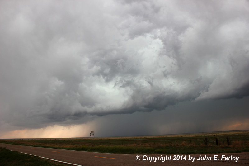
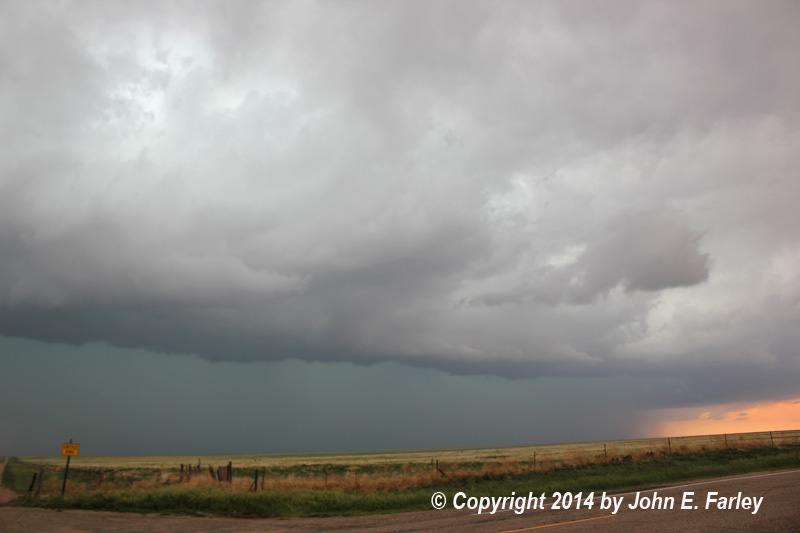
The storm was cycling again now, but the new wall cloud this time was much less impressive than earlier one. The storm has evolved into more of a linear MCS now, as new convection has gone up on the outflow extending northeastward to the north of Kim and on toward Springfield. I retreated east toward Kim, stopping for occasional pictures. A picture of the cell that had earlier produced the tornadoes can be seen here and another one up the line just north or northwest of Kim here.
By 3:15, the TOR warning for the cell that produced the tornadoes was replaced with a SVR warning, and the other cell up the line to the north of Kim also had a SVR warning. I began to be concerned that the cell north of Kim would surge SE and block my route to Springfield - don't want to get into large, wind-driven hail. At 3:17, the cell north of Kim was upgraded to a TOR warning. When I got back near Kim I managed to get radar back for the first time in quite a while and could see that, behind the gust front and heavy precip to my north, there was an inflow notch I couldn't see visually, and that is where the potentially tornadic circulation was located.
I sit in Kim for a while until heavy rain and a little hail started to fall, then edged back south to where 160 turns west (it runs briefly N-S as it goes through Kim) and sat there until the hail passed Kim. Route 160 between Kim and Springfield was now obviously in intense rain and likely hail with a possible rain-wrapped tornado in there - I had NO desire to punch that! (No tornado occurred there, but there certainly could have been one.) To my west, heavy precip was breaking out along 160 west of Kim, so I decided my best option was to punch north through the relatively weak part of the line, now north of Kim between the intense cells to the east and west. This worked fine, no hail and not a lot of rain, but I did see flooded fields, high streams, and some hail on the ground.
About 10 miles north of Kim, I stop to watch the storm to my SE and get some pics of the increasingly impressive mammatus that has formed:

At this point, the only real option is to head north to La Junta - farther north than I wanted to be with the best potential the next day in NM, but at least there was still a SVR-warned storm in the middle between Pueblo, La Junta, and Walsenburg that I might be able to intercept. I worked through La Junta and toward the storm, but it was weakening rapidly, so I returned to La Junta to get a room for the night, and then a celebratory steak dinner at Boss Hoggs. Interesting note - there is a restaurant by that name 3 blocks from our home in Pagosa Springs, so I asked my waitress if there was a connection between the two restaurants. She said, "Yes, my mom and dad own both of them."
A few final thoughts: Although I knew the setup was good, I never really thought that I would see tornadoes as big and spectacular as these were. I do wish I had not gone so far east so I could have gotten back west in time to get a closer view of the tornadoes, but even from my distance they were quite photogenic, so no complaints! In fact, I would have to rate this as an all-time top five chase for me. I guess my only remaining question is whether I saw two tornadoes or three. My sense is that it is more likely three, but I may never know for sure. That also seems to be the dominant opinion among the relative handfull of chasers who were on this storm, several of whom were closer to the tornadoes than I was. After reviewing other chase reports and videos and discussion with some of the other chasers on the storm, my opinion is that there were two separate tornadoes associated with the second meso, so a total of three tornadoes for the storm. For now, NWS Pueblo is counting two and rated both of them high-end EF-1 based on damage to trees, fences, and powerlines. There was one minor injury from the first of the two large tornadoes, and route 160 was temporarily closed after the second one blew down power poles and lines across the road. When I passed that spot the next day, there were still power company crews working there, and it was interesting that the barb-wire fence along the road was plastered with tumbleweeds in the area where the tornado crossed the highway.