

By the time I had eaten a quick lunch in Laverne, storms were starting to fire just to the west along the OK/TX panhandle border - but didn't really seem able to get organized, firing and quickly dissipating, and somewhat getting sheared apart by the strong upper winds from the south. A stronger supercell and later, a line with embedded supercells, formed well west in the TX Panhandle - farther west than I expected, and also well to my south, with some of the storms trailing back across I-40. It turns out that the dryline was farther west than I expected at initiation, so I should have started out even farther west than I did. I waited a while to see if the closer storms would intensify, while watching the ones well to my west and southwest in the Texas Panhandle. I suffered from lots of indecision on this chase - more than most, for sure - and this was one of the times where I was most indecisive, starting west, north, south, etc. but never going very far as I changed my mind about what would be the best chase strategy or the best storm to go after. Then a very nice-looking storm fired not too far to my east, just west of Woodward. I went after it to the edge of Woodward, but it accellerated northward away from me and weakened. Turns out this was a poor choice anyway, because to get to Woodward I had to go south to Purcell from maybe 10 miles north of there before I could go northeast to Woodward. So even though this storm was not far to my east when it initiated, it was well to my northeast by the time I could go in that direction.
By now there are tornado warnings in the TX panhandle line of storms, although the supercell has weakened. It's nearing 3:30, and I've been wandering indecisively for 3 hours, starting toward storms then changing my mind as they weaken or seem unreachable. Time for a decision; I decided I needed to go for the storms coming out of the Panhandle, even though they were linear. And at least they did have tornado warnings and appeared to have multiple mesocyclones embedded in the leading edge of the line. If I waited any longer, these storms would have overrun me before could I get south enough to get on them. So south I went, on the paved back road that goes south from Fargo, continuing across route 60. The road-atlas map I was using to navigate to the general area of the storms said this road goes through and turns west to 283, but in reality it does not. I then looked at another, more detailed map and could plainly see that the first map I looked at was wrong. More time wasted! So, I had to double back to 60, go west and down 283 - and somehow I still just beat the storm to Roll, OK.
From Roll, I was more or less chased east by the surging bow echo to route 183 a little south of Putnam, where I was overtaken by the storm. It was about 4:20 when I set up just west of Roll and was watching the severe line of storms approaching, as the last remaing TOR warning expired. At this time, the storm looked totally outflow dominant, and the shelf cloud was not all that impressive. That would change soon, though.
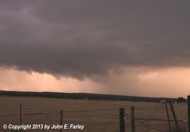
From about 4:30 to 5:20, I raced east just ahead of the line of storms on route 47 from Roll to just south of Putnam, occasionally making quick stops for pictures. Increasingly with time, the storms would nearly catch up to me every time I did this, even if I moved pretty far ahead. After a few miles, I noticed that there was a distinct wave in the line to my southwest, suggesting the possibility of an embedded circulation or mesovortex. As I moved east, this continued to shift northeast directly toward me. Since I wanted to get ahead of it before it crossed the road I was on, I was now not stopping at all but just trying to keep ahead of the storm. I did snap a few pictures of the wave in the gust front through the passenger window of my car; this was the best one I managed to get, with the wave maybe just a mile or so away. A highly enhanced version to show what the dark underside of the cloud looked like can be seen here - sure wish I had some video to see what kind of motion was going on there.
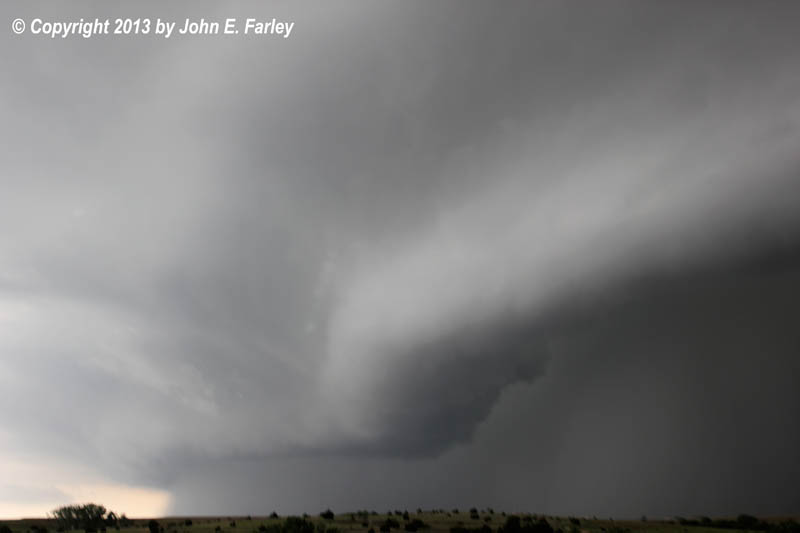
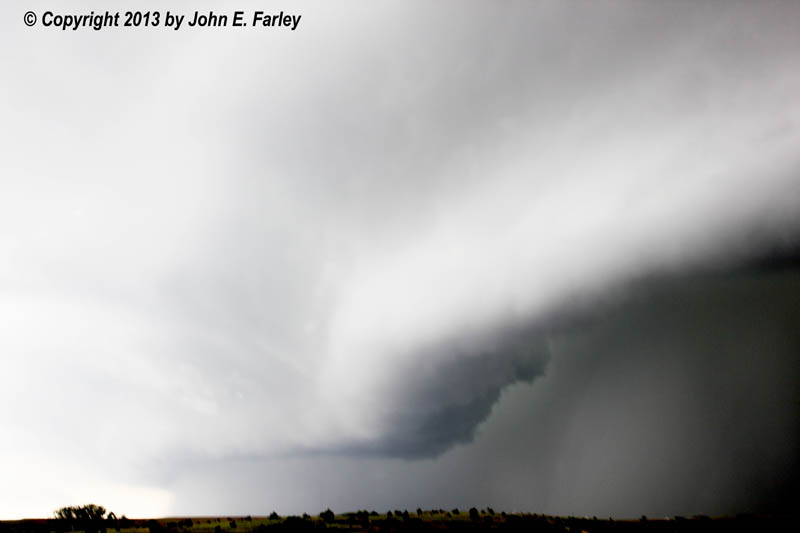
At one point midway between route 34 and route 183 the road bends SE for a couple miles, and this is where the storm briefly caught up to me, with the wave in the line literally right at my back. At ths time, I encountered bursts of intense rain and wind from the southeast, suggestive of some embedded rotation in the wave (technically, LEWP - line echo wave pattern). But the leading edge of the rain never got more than a quarter mile or so ahead of me, and once the road turned east again, I was able to gun it and get back ahead of the surging storm. Now back just ahead of the storm, I could barely gain on it going 70+ mph. And indeed, in one severe weather statement, the forward speed of the storm was reported to be 70 mph. As the storm surged and accelerated, the shelf cloud became more and more spectacular. I was able to stop just long enough to get a few pictures of the spectacular shelf cloud, first with a camera with a regular 18-55 lens, then with another camera with a wide-angle 8-16 lens. The first picture below was taken with the regular lens looking northwest; the second one with the wide-angle lens, at its widest setting, looking southwest:


Shortly later, around 5:20, I had to jog south a few miles on 183 in order to continue east on 47. When I did this, the storm immediately overtook me, and I encountered rain and intense crosswind from the west as I went south to where 47 turns east again. Around time, a 58 mph gust reported just north of Putnam, not far north of where I turned south and was overtaken by the storm. Other locations in the Texas panhandle and western Oklahoma received wind gusts as high as 70 mph from this line of storms.
Since I was now in the rain and wind, and the leading edge of the storm was getting farther and farther ahead of me, I stopped trying to race the storm and let it pass over. Moderate rain and wind continued, but nothing nearly as intense as what I had encountered along route 183 and when I first turned east again on 47. Radar was now showing a slower-moving, more broken line of storms to my southwest, with the main bow echo surging northeastward through Woodward County, northeastern Dewey County, and into Major County. I consider calling it a night and looking for hotel but when I got back to 183 it looked fairly bright to the south, though dark to the SW - where another cell down the line was still producing severe wind. Farther to the southwest, a storm on tail end of line near where I-40 crosses between the TX panhandle and Oklahoma appeared to be taking on supercell characteristics, so I decided to head south and go after it.
I got a few big raindrops but nothing more from the storm to my west, and had an easy trip south into Clinton for a gas stop and to pick up I-40 to head west to intercept the tail-end supercell south of Elk City.
As I thought I could from the radar, I was able to beat the tail-end supercell into the Elk City area, then drop south on 6 and go west on 152 for an intercept. Between 6:55 and 7:15, the storm I was targeting produced hail ranging from 1 to nearly 3 inches in diameter along a path south of Erick and Sayre. By 7:45 or so I was on the storm, on route 152 SW of Elk City. This storm was definitely a supercell. It had small lowerings at times under the updraft, but not a real pronounced wall cloud for the first several minutes I was on the storm. Around 7:50 a tornado warning was issued. Around the same time the TOR warning was issued, I noticed that a wall cloud had formed, and for the next 15 minutes or so, wall clouds would form and dissipate. Then, around 8:05, a more pronounced wall cloud formed and lowered. I soon noticed another lowering behind it, largely wrapped in rain. This feature appeared to lower toward or to the ground around or just before 8:10, well to my SW. At 8:10, a brief tornado was reported 11 miles SSE of Sayre - roughly where I could see the rain-wrapped lowering. I am quite sure that, somewhere in about a 3-minute time frame, I was looking directly at the rain-wrapped tornado, although it was impossible due to the rain to pick out any feature that I could definitively call a tornado. But twice on the video I say that I am suspicious of a rain-wrapped circulation, and what I was looking at was in just the right time and place relative to the tornado report 11 miles SSE of Sayre. The video capture below, taken near the time of the tornado report, shows the rain-wrapped feature in the right-center of the picture:

After a few minutes, it appeared that the circulation that produced the tornado was occluding and the lowering closer to me was becoming the primary meso. A picture from around that time can be seen here. It's possible the tornado could still have been going on in the rain back there under the occluding meso, but shortly after this time the more distant feature dissipated and the one in the foreground became dominant. This new circulation was moving directly toward me or even might pass to my south, but was not moving real fast. Here is a video capture of it that I got before I made an eastward adjustment from the same place as the captures above were obtained:

With the relatively slow movement of the storm (a total contrast to the surging bow echo I was on earlier), I could make a series of eastward moves and photo stops without having to be too rushed about it. I saw a large tour group (3 vans) at the intersection of 6 and 152. I think it was probably Roger Hill's group, but am not sure. I moved a couple miles farther east of there and stopped for more video. The wall cloud tightened up and took on more of a funnel appearance, though I am not sure how much if at all it was rotating. Here is a picture:

This occurred just about the time the TOR warning expired and was replaced with a SVR warning, and it did not persist for too long. By now it was just to my NW, having crossed route 152 from WSW to ENE, probably near route 6. Just as I shut down my camera and prepared to move east, an intense positive lightning bolt struck near there followed by thunder that sounded like a couple large explosions.
I continued to follow the storm, now just SVR warned, east to Cordell as darkness fell. As I watched the storm, the sirens in Cordell began to blow as lightning illuminated a large lowering just NW of the town. Although the storm was no longer TOR-warned, I think this video capture shows the reason why the sirens were blowing. But this feature disappeared into the rain after a few minutes, and I knew the chase was over. It was time to head back to Elk City and try to find a room ahead of the hordes of chasers - hotels around there are always pretty full due to oil workers, and now there were lots of chasers, too. I did stop once to videotape the nearly-continuous lightning to my northeast, as the storm produced 1 to 1.5 inch hail around Corn and Weatherford.
The Days Inn in Elk City was full but I managed to get a room at the Ramada Inn at the same rate I had paid the night before at a Super 8. At a convenience store near there, I heard that the Dominator had been there earlier, along with lots of other chasers. Also there were several other chasers at the Ramada Inn where I was staying. After the my initial confusion and indecisiveness, this turned out to be a good chase day - one of the most spectacular shelf clouds I have ever seen, and my best shelf-cloud photos to date, and a supercell and a tornado, even if it was hard to pick out through the rain.