
I started the day in Childress, TX where I had ended up after the previous day's chase. Although severe weather would be possible over a large area again today, it appeared that the most concentrated area of severe weather would be somewhere around the eastern end of the OK panhandle NW into Kansas. Three reasons led to this general target area. First, the models were showing some bulging or bowing of the dryline so that it would be negatively-tilted in this area, i.e. aligned from NW to SE. This would allow for backed (southeasterly) surface winds ahead of the dryline, creating greater directional wind shear and enhancing the chance of tornadoes. Second, extreme instability was forecast for this area, and by the middle of the day was already being realized over the northeast part of the Texas panhandle. This would make conditions favorable for very intense updrafts and rapid storm development. Third, an outflow boundary from overnight storms would also be present, extending roughly from a point in western KS where it intersected the dryline southeastward into northern Oklahoma. When storms cross or move along such boundaries, they often intensify or become more prone to storm rotation. The area between the dryline and the outflow boundary was where the extremely unstable air was, setting up a situation in which storms might initiate along or a little ahead of the dryline, rapidly intensify in the extremely unstable air, and become more likely to produce tornadoes as they neared or moved onto the outflow boundary. SPC was also focused on this area, painting its highest tornado probabilities for the day (10% within 25 miles of any given point) in this area. I figured I would initially head to Woodward, OK, check data, and possibly work my way a little farther north or northwest, possibly to somewhere near the KS/OK Panhandle border.
The chase
This would turn out to be one of my best chase days ever today with six tornadoes from near Minneola, KS north through the Dodge City area. This isncludes two tornadoes that were each rated EF-3, and two that were rated EF-2. I also got pictures of two other smaller, more brief ones. NWS damage surveys have now been completed and their results posted to the NOAA Storm Events Database, and this report has been updated accordingly. The three major tornadoes that I was able to see and document for much or all of their lives took on just about every shape a tornado can - elephant trunk, cone, wedge, multi-vortex, rope, you name it. And two on the ground at the same time, too - 3 different times! A spectacular display of Mother Nature. Here is the story in detail:
There were lots of storm chasers around by the time I got to Woodward, including DOW and NSF research vehicles. It did indeed look like I needed to get a little farther north or northwest. NWS Amarillo in their updated discussion was looking for storms to initiate in Beaver Co., OK in the Panhandle, west and a little north of where I was. CAPE had now reached an extremely unstable 5500 in the northeast TX panhandle according to the SPC mesoscale analysis, with a tongue of high CAPE stretching northwestward into SW Kansas between the dryline and outflow boundary, both of which were visible on different radars. Everything seemed to be coming together. I moved north to Buffalo, OK, made another pit stop, and waited a little longer. Lots of chasers hanging out there, too. But I did not have to wait for long. Soon I could see big, hard updraft towers surging into the sky to my northwest. I could see visually that one of them was quickly becoming a powerful storm, even before there was any evidence of it on radar. I decided to blast north, with a strategy, anticipating northeastward movement of the storms, of getting at least to where I was due east of the storm before going west. I thought this might happen just before I got into KS, but I was there before I was due east of the storm, so continued up to U.S. 160. It looked like the storm, which was initialy moving NE, was going to go right over Minneola, KS, which is located on U.S. 283. So rather than going all the way to 283 and then north, I turned north on a back road about halfway between where I had turned onto 160 and where 283 goes north in to Minneola.
The first EF-3 Tornado
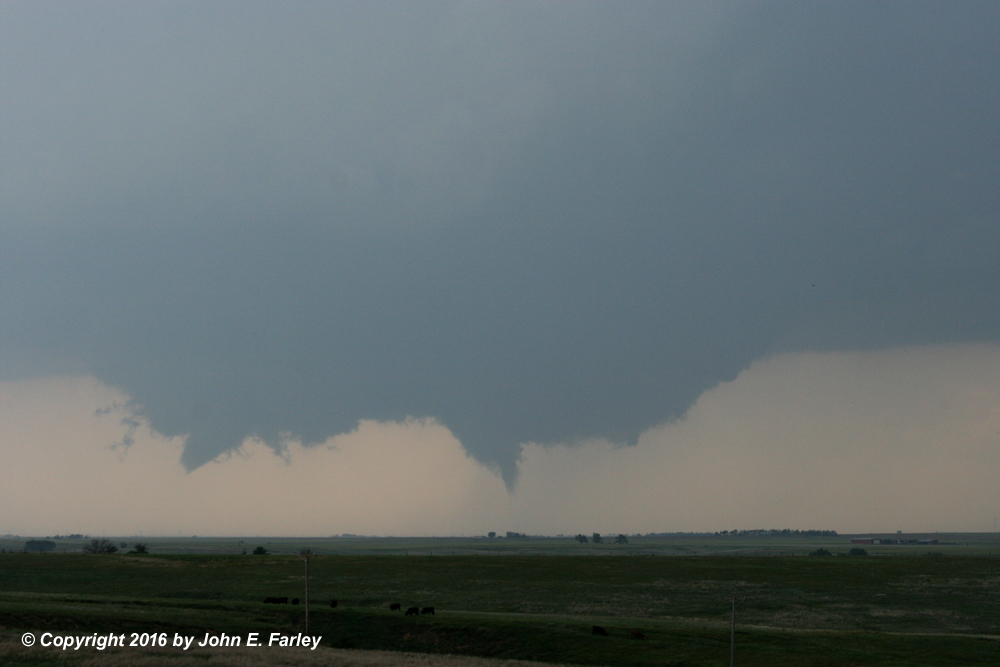
Very soon the storm got a SVR warning, then a few minutes later a TOR warning. The first TOR warning was at 5:21 p.m. Although the warning mentioned that spotters had reported a funnel cloud, I saw none at this point, and there was a flat (but wide and impressive) updraft base with no wall cloud yet. But one soon formed, and then became something like two side-by-side, almost connected, wall clouds, each of which appeared to have its own rotation (something comfirmed by some radar velocity images I saw later) and, after a while, both began to produce funnels. I figured it was very possible that at least a brief tornado may have occurred with funnels under either or both of the wall clouds, and this was indeed the case. Damage survey information from the Dodge City NWS reveals that the long-track EF-3 tornado associated with the southwestward of the two mesos began, at least intermittently, at 5:55 p.m., though I was not sure it was a tornado until ten minutes or so after that. Also, about 4 minutes later per the NWS, a brief tornado occurred under the other meso to the northeast. In this picture, you can see the early stages of the EF-3 tornado on the left, and a funnel on the right that extends at least halfway to the ground. This is probably the brief tornado that occurred under this meso, but this was one of a series of funnels that occurred under this meso, so it could have been another one that produced a brief ground circulation. From my distance I could not see if there was a circulation on the ground under either funnel, but per the damage survey, there was under the left one and may well have been under the right one. So more likely than not, this was the first of several pictures I got showing two tornadoes at the same time.
Eventually, a larger and better-defined funnel formed under the left wall cloud, which was producing a tornado before I could visually confirm it. Reviewing my video, it seems pretty clear that it was a tornado by 6:00 p.m, but in actual fact it was a tornado even before that. I was fortunate to be able to get zoomed, tripodded video of the first 10-15 minutes of this tornado. Even though it was pretty far away (more than 10 miles from my location when it formed, and moving somewhat away from me), contrast was good for the first 10 minutes or so of the tornado, and the cloud motion, including rotation in both wall clouds, was very powerful and impressive. It was a few minutes after my video confirms a dust swirl under the funnel that I was visually certain that it was indeed a tornado, and eventually the condensation reached all the way to the ground. For a while, this was intermittent, though the tornado was down the whole time. Here are some photos of the early stages of this tornado:

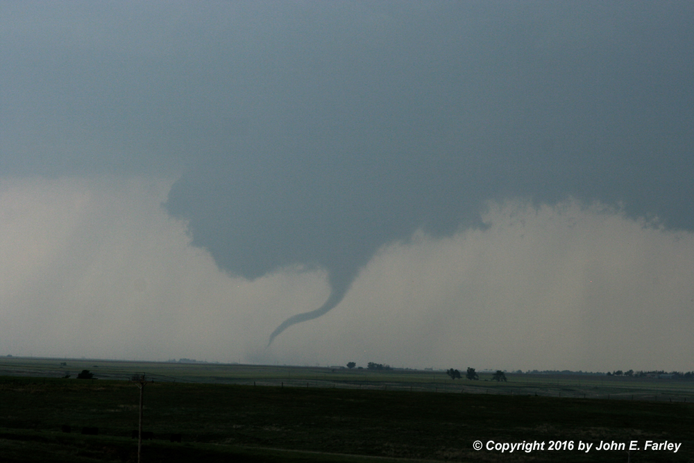

Around 10 minutes or so after the time my video confirms a tornado, it began to get more rain-wrapped from my perspective, and contrast worsened, so I began to stairstep northwestward on the back roads. Although the mid and upper winds would have suggested that the tornado should have moved northeast, it actually moved more due north, gradually taking it farther from me. In hindsight, I should have moved to the NW sooner than I did, but I was getting tripod video of a beautiful tornado so it was hard to move. At some point as I was working my way to the northwest, I noticed that the tornado had become a large, violent-looking tornado with an appearance very similar to the Rozel tornado in 2013 - except that from my perspective, I was looking at it through the rain, so it was lower contrast than my images of the Rozel tornado. Congratulations to chasers who were farther northwest than I was, and got much better views of this stage of the tornado. But at least I saw it and was able to photograph it when it was in this stage:


Several minutes later, I could see the ropeout of the tornado through the rain. That was about 20-25 minutes after I had first been sure that this was a tornado. But as I mentioned, my video showed that it was down before I was sure it was a tornado, and the damage survey as reported in the NOAA Storm Events Database indicates that the tornado was on the ground for 30 minutes, from 5:55 p.m. to 6:25 p.m. This EF-3 tornado had a path length of 14.7 miles and a path width of 675 yeards.
Toward the end of this tornado, another one formed to the east of its track. This tornado, rated EF-2, was well documented by a number of chasers who were closer to the tornadoes than I was at this point. I could not really see this tornado very well through the rain, but as discussed in the update below, I do have a couple pictures of it, along with another tornado that I was unable to verify earlier but can now.
Here is video showing the formation and early stages of the First EF-3 tornado:
The NWS description of this tornado, as reported in the NOAA Storm Events Database, can be seen here.
The NWS description of the brief EF-0 tornado that formed under the other meso northeast of the early stage of the EF-3 tornado can be seen here.
Update - Two More Tornadoes
Having now compared my photos and video with video by Matt Magiera, who videoed the storm from the same direction I did but closer, I can confirm that the tornado in the aforementioned pictures is indeed a new one, almost certainly the first one rated EF-2 by the Dodge City NWS. I can also confirm that another feature in the same picture is an additional tornado, since Matt's closer video confirms that it was. Here is my picture:

The picture is not of high quality due to distance, rain between me and the tornadoes, and cropping - but it is sufficient to document the tornadoes. In the picture, you can see a good-sized cone tornado at the left of the photo, partly obscured by rain. Comparison with Matt's video confirms that this was a new tornado, not the original EF-3. Almost certainly it is the first EF-2 tornado surveyed by the NWS, as the timing of the Storm Events description also supports this conclusion. In the right portion of the picture, to the right of the tower, you can see a needle or rope-like feature between the two larger lowered areas. Matt's video confirms that this was also a tornado - it clearly shows the narrow funnel extending to the ground with a dust swirl. Hence, this picture documents two additional tornadoes beyond the two EF-3 tornadoes, the other brief EF-0 tornado, and the other EF-2 tornado discussed elsewhere in my report, bringing my total to the day to six tornadoes.
The NWS description of the EF-2 tornado in the left of the picture above can be found here.
The NWS description of the brief EF-0 tornado in the right of the picture above can be found here.
The Long-Track EF-2 Tornado
Since the rain was blocking my view, I decided to get west to U.S. 283 and head north. From the last place I stopped on the side roads, just to the east of 283, I could see that traffic was badly backed up on 283. I did not know at the time that this was apparently due to a rolling police roadblock that was in place for a while. But the traffic began to move again, so I decided to get on 283 and head north. At this time there was a large wall cloud to my northwest, or more accurately what appeared to be two adjacent, almost-connected wall clouds, much like what I had seen earlier. But soon it was evident that a large tornado was down under the left side of the left wall cloud. I stopped two or three times and got video and some photos, as this very large tornado morphed among various forms including wedge and multi-vortex. This tornado did not appear quite as intense as the earlier one, but it looked bigger. And it was dangerously close to Dodge City!


On my second or third stop to video this large tornado, I noticed that a lot of thunder was coming from my southwest, and looked back that direction to notice that an intense storm had gone up just to my SSW and was backbuilding toward the northwest. I knew that if I did not get out of the way, I was about to be in a nasty hail core. So I started driving north again on 283, hoping that if I could get far enough north I could cut west ahead of the new storm and avoid the hail while still being able to see the tornado. I continued to video the tornado as I drove along in the slow, at times stop-and-go traffic. The tornado gradually became better backlit, and evolved into a cone and eventually into a prolonged ropeout stage. And it was moving along faster than I could in the traffic, gradually looking farther and farther away.


This tornado was the longest-track one from this storm, with a track length of 15.6 miles, from 6 miles SW of Dodge City to 14 miles NW of Dodge City. It was also the widest, with a maximum path width of 1800 yards - a mile-wide tornado! The widest I have seen in my chase career, and my first bona-fide wedge! Addditionally, this tornado was, during its early stages, analyzed by DOW (doppler on wheels). Wind speed was briefly, just after the tornado formed, measured at 90 meters per second, or 200 mph. Wind of this speed is enough to cause EF-5 damage, but the tornado was rated EF-2 because that was the greatest damage done to anything it actually hit.
Here is my video of this tornado:
The NOAA Storm Events database description of this tornado from the NWS in Dodge City can be seen here.
The Second EF-3 Tornado
After a while the rope stage of the above tornado, still down, was getting harder to see in the rain, but the eastern wall cloud was now rapidly getting organized, and soon dropped a new, good-sized tornado to my NNW. At first I thought this tornado might be in Dodge City, but fortunately it was a little farther away, to the north of the city. With the rope still down, I again had two tornadoes at once! (Though at the time, this was the only one I was immediately sure of out of the three incidents of it that I experienced.) In the left of the picture below is the ropeout of what earlier was the wedge tornado southwest of Dodge City (the long-track EF-2 Tornado). In the right of the picture is the new tornado that formed just north or northwest of Dodge City (the second EF-3 Tornado)

I continued north in the stop-and-go traffic, mesmerized by the new tornado to my north, and at the same time trying to figure out how to avoid the hail core that seemed to be closing in on me as I crawled along in the slow traffic. Here are a couple more pictures of this second EF-3 tornado:


This tornado began eight miles north of the Dodge City airport and was on the ground for 1.9 miles and about 10 minutes. It destroyed the building at the Dodge City landfill and threw a large propane tank onto a road.
Here is my video of this tornado:
The NWS description of this tornado in the NOAA Storm Events database can be seen here
As I was watching this tornado, the storm to my southwest was growing and getting closer. With lots of stop-and-go traffic, the storm was gaining on me and I could increasingly see that west was not going to be an option. When I finally got to the edge of Dodge City, I could see that there was a gas station with a roof over the pumps on a crossroad if I turned right. By now considerable rain and some hail (I would guess around an inch diameter, but not sure) was falling, and the tornado to my north was disappearing in the rain. I had to wait a couple of stop lights, but was able to get under the roof and out of most of the rain and hail. The rain gradually intensified, but the hail did not and soon it was all rain, driven by 40-50+ mph wind from the southeast. And then the sirens began to blow. (I later heard they had been blowing off and on for 3 hours in Dodge City due to the repeated storms and warnings). The sky seemed a little lighter to the southwest, and I got out and verified that there was no tornado visible to my SW or S, so figured they were just blowing the sirens because of the new SVR warning that had been issued. Gradually the rain let up, and I headed into Dodge City to see if I could find a place to stay. But soon I noticed that the power was out nearly everywhere, at least in the western part of town where most of the lodging and restaurants are, along route 50. So I decided I had better head west and find another town to stay in, but that did not work out either, because at the west edge of town, 50 was closed where the tornado (the long-track EF-2 tornado detailed above) had crossed the road. I later learned that poles and wires were down and that a semi was overturned in that area. So I headed back east, and eventually found one motel (The Wyatt Earp Inn) and a restaurant next door that had power. Miraculously, the motel still had rooms available, so I got a room and went next door to eat steak. While I was checking in and unloading the car before dinner, I noticed anti-crepuscular rays stretching across the sky, and a nice rainbow in the southeast. And then while eating dinner, I noticed impressive sunlit mammatus out the window and mentioned them to a long-distance trucker and his wife that I had been chatting with. They pointed the mammatus out to others, and soon nearly the entire room emptied into the parking lot to view the show. When Mother Nature puts on a show, she really does - tornado after tornado, anti-crepuscular rays, a pretty rainbow, and sunlit mammatus, all from the same storm. Here is a phone picture (all I had by then) of the mammatus:

On the way out of town the next day, I crossed 2 damage paths, one about a half mile wide running roughly south to north along the east side of U.S. 400 where it connects between U.S. 50 and U.S. 56 SW of town (from the EF-2, long-track tornado that I saw), and another narrower one farther west, a few miles east of Ensign crossing U.S. 56 (from near the end of the first one I saw).
Here is a map showing my chase route and, per the Dodge City National Weather Service's preliminary reports, the tracks of the major tornadoes:

It should be noted that in the final analysis the tracks of some of the tornadoes were rather different, and a total of 11 tornadoes were found. Hence, the tracks here should be regarded as very approximate. Also the tornado shown here as EF-1 was upgraded to EF-2 after further analysis. The numbers 1 and 2 on the map show the approximate locations from which I watched the first EF-3 tornado. I tracked the long-track EF-2 tornado as I travelled from approximately number 3 to number 4, and the second EF3 tornado as I travelled from number 4 into Dodge City.
Return to 2016 Severe Weather Observation page
This page last updated August 19, 2016 (also updated on May 28 to add the map showing chase route and tornado tracks and on May 30 to confirm two additional tornadoes). The final update on August 19 incorporates information from the National Weather Service as reported in the NOAA Storm Events Database.