
Storm 1 - A squall line in the OK Panhandle and southwest KS
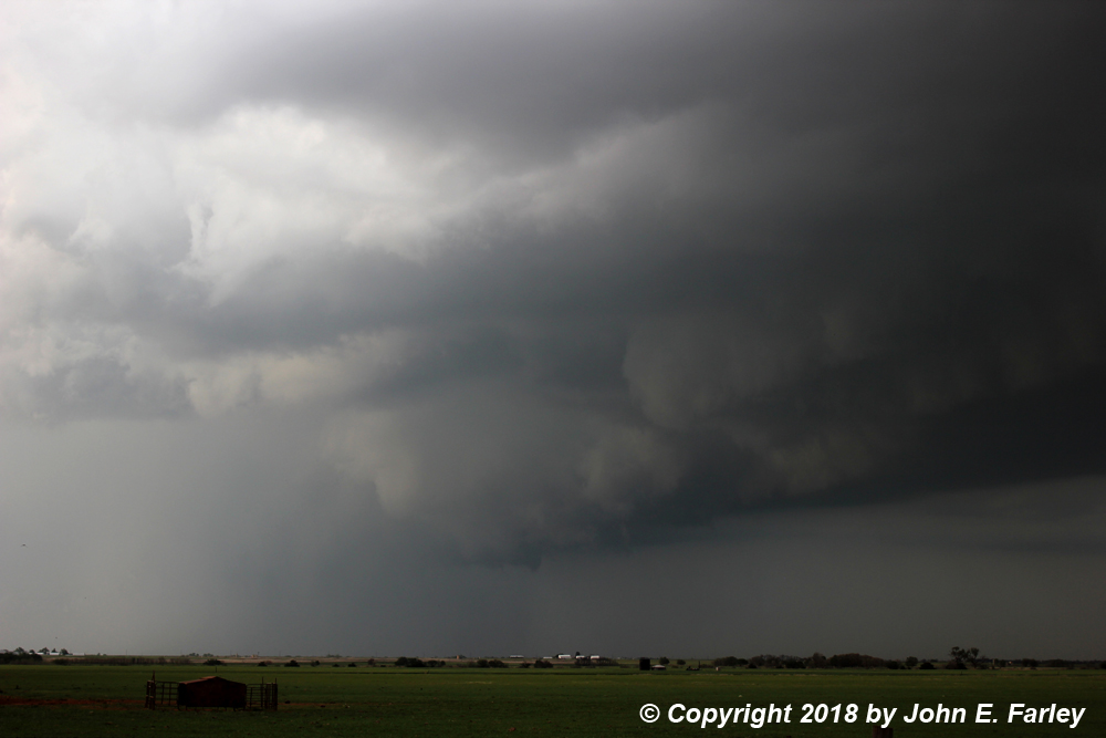
As I headed south and west from Hutchinson, it eventually became evident that I would need to go farther west than Coldwater. The morning model runs had predicted fairly early initiation of storms in southwest KS, with lots of storms almost right away. The "early" and "lots" parts happened as predicted, but the storms initiated a bit farther southwest than predicted, in the OK Panhandle and the northern TX Panhandle rather than KS. This meant I would have to go farther west and south to intercept the initial storms than I thought - so I continued south and west from Coldwater through Protection and evenutally to a spot just northwest of Ashland, KS, where I had a good view of the storms. When the storms first started in the Panhandles, there were probably one or two that were supercellular, since in the very early stages of the storms there were reports of 2.5 inch hail, and one or two of them looked intense and somewhat isolated on radar. However, the storms quickly became multicellular (though they continued to get SVR warnings), and this first view of them a little before 2:00 p.m. from near Ashland tells that story pretty well:
While shelf clouds like this one look menacing and are often accompanied by severe wind and/or marginally severe hail, they are usually a sign that the storm is outflow-dominant and, when they extend across much of the sky, linear. Which is exactly what this storm was. When I took this picture, there was warm, very moist, and fairly strong inflow from the SE. But soon I was overtaken with cold outflow from the NW, the temperature dropped, and the storm looked even more outflow-dominant. Pretty photogenic, though, especially with a wide-angle lens:

As predicted, by now the storms were building up the line to the northeast across KS, with lots of severe thunderstorm warnings from the OK Panhandle all the way up into central KS. The part of the line I was on and other parts produced a number of marginally severe hail reports, heavy rain, and a bit farther northeast, severe wind as well. Later in the day (after 4 p.m. and into the evening) there were a number of tornado reports in northern and eastern Kansas (including, once again, Tescott and Culver - I guess the real chase strategy would have just been to camp out there for two days). However, I have not seen much in the way of chaser reports on any of these, which may have been hard to see due to the multicellular nature of the storms, and most chasers were farther south.
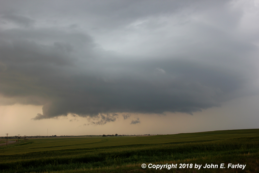
At this point (around 2:15 or 2:20), I probably should have cut my losses and just headed south or SE for the more isolated storms now cropping up in western OK. That is what I started out to do, returning to Protection and heading south on 183. But when I got to Buffalo, OK, I could see visually and on radar that the then-tail-end storm, then near Slapout, OK looked like it was intensifying, so I blasted west then south from Buffalo to Laverne, OK, where I found a viewing spot on the west edge of town. On the way there I could see a distant lowering under the updraft that may have been a short-lived wall cloud, but by the time I had a good view from Laverne the storms were every bit as outflow-dominant as they had been earlier in KS. On the way there I had gotten back into the warm inflow, but now I was in the cold outflow again. There was a 10-12 degree difference in a few minutes crossing that outflow boundary. At this point it was evident these storms were outflow-dominant and staying that way, so it was time to leave them and try to intercept a more isolated storm to the south.
Storm 2 - A supercell in northern Oklahoma
I was fortunate to have a NW-SE road in US 412 to Woodward and US 270 southeastward from Woodward that I could, hopefully, use to cross just ahead of a supercell working its way northeast toward Oakwood, OK. I figured that it would take the highway there and that with luck I could cross just ahead of the storm and get a good view. Although the need for a gas stop and encountering some construction along 270 made this a little tighter than I was hoping for, it worked! And as I was nearing Oakwood, the storm, which had weakened somewhat after dropping very large hail earlier near Sweetwater in far western OK, suddenly ramped up again. It suddenly developed a meso signature which continued for several radar scans, and a few minutes later rapidly intensified. A new SVR warning was issued for 60 mph wind and 1.5-inch hail. I stopped just NW of Oakwood and could see a wall cloud coming directly toward me:

This picture was taken at 5:12, 13 minutes after the new SVR warning was issued. I took video as the wall cloud came toward me. There was a lowered area under the wall cloud, which at first I could not tell whether it extended to the ground, but as it got closer I could see that it did not. At least halfway down, though. At first it seemed to have the shape of a funnel, but in the low contrast I could not tell. Gradually it seemed to take on a little more of a bowl shape. In the two video captures below, the first is how it appeared around the middle of the time I was watching it, when I thought it could have been a funnel but could not tell in the low contrast. The second is a video capture at the time of a flash of lightning, which offers a little better contrast.


If you want to see for yourself what you think, you can see my video here:
A minute or two after I got this last capture, I knew it was time to get out of there - I was not going to let this pass over me. There were a couple other chase vehicles also watching from this spot, and both left about the same time I did. As I bailed a few miles SE on 270 to where it turns east, I was blasted by strong RFD winds I would estimate at around 50-60 mph with lots of blowing dust. About where 270 turns east, I was out of the worst of that, and stopped to get a few pictures. The pronounced lowering that had been moving toward me seems to have mostly lifted by then, but the storm structure remained impressive:

From here I pursued the storm all the way northeast to Waukomis, just south of Enid, over the course of the next hour and 45 minutes or so. For a while it weakened, but then it reintensified and got a new SVR warning at 6 p.m., about an hour after the previous one was issed and 15 minutes after it expired. At times it showed some nice structure, as in this picture around 6 p.m. and this one just after 7:00. Around 6:30 it dropped 1.5-inch hail on Drummond. By a little after 7:00 p.m. I figured it would be hard to keep up with it, and I did not want to get farthe northeast when I needed to return home the next day. Still, I think it did produce some additional severe weather later. I headed south to El Reno to get a place for the night.
As I neared El Reno, the storms that had been supercells in southwest OK were approaching the OKC metro area, now a large and increasingly linear MCS. Soon, the setting sun appeared in the west under the clouds above me, and a beautiful rainbow formed to my southeast, just as I was coming into El Reno:

As I was ending my 4-day storm observation trip in El Reno, this seemed like a highly appropriate way for my trip to end. RIP Tim, Paul, and Carl - can't believe it has been 5 years!
As it turns out, though, the storms were not quite through with me and certainly not through with the OKC metro area. I had initially thought from their movement that the storms would have shifted east of El Reno by the time I got there, but a new cell formed on the back side of the line southwest of there and surged over El Reno just as I got there. I was greeted with howling southeasterly winds and near-horizontal rain, as I got what was probably the last room available in town. Apparently there were a lot of people who did not want to drive in howling winds and horizontal rain, and that was a good decision on their part. There were numerous high-water rescues involving cars all over the OKC metro, and shortly I got that last room, a tornado from a circulation toward the front part of the storm complex cut an 8-plus mile path through Norman. This tornado occurrred just after dark and was likely rain-wrapped: despite its moving through the storm-chasing capital of the world (Norman), I have not seen any video of it. Just horizontal rain, like what I experienced.
Here are two maps showing my storm-observation routes for the day. The first shows the roads I used to observe the squall line in KS and the OK Panhandle; the second the roads I used to observe the supercell in Oklahoma:


Chase distance for the day: 455. Total chase distance for the 4-day trip, including return mileage going home the next day: 2153 miles.
Return to 2018 Severe Weather Observation page