by John Farley
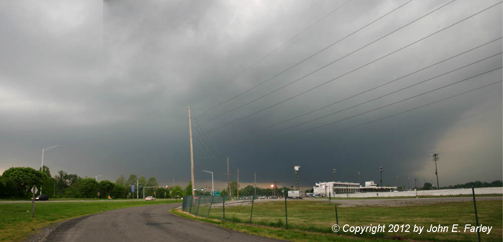
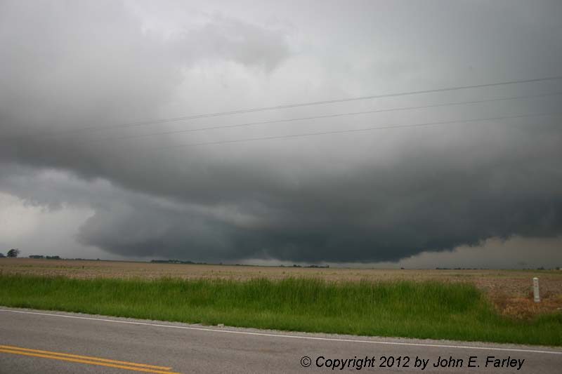
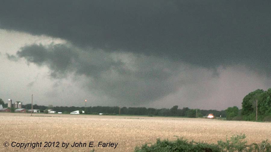
At first, all of the storms were well north of the warm front, elevated convection over the cooler air near the ground in northeast Missouri. But by early afternoon, a supercell formed near the low pressure center and much closer to the warm front, near I-70 out to the northwest of the St. Louis area, just west of Warren County. At first this was moving to the ENE, which would have taken it eventually over Macoupin County, IL. But since it was well to the west - a couple hours away when it formed, and would not pass too far from Edwardsville whatever way it moved, I had the luxury of waiting, watching, and getting some stuff done at home as it moved my way. Often strong supercells will turn to the right with time, and that is exactly what this one did - in fact, it became a classic right-moving supercell. By the time it was within an hour or so of me, it was moving just north of due east, a path that would bring it right toward Edwardsville. It was time to start loading the chase gear in the car, get the equipment working, and head out. I headed west on I-270, and decided to stop at the closest spot I knew to the Mississippi River that had an open view but was still near near I-270. This spot is not far from the IL route 111 exit. This would let me get on the freeway and blast east if I had to in order to stay ahead of the storm, or use I-255 to shift south if the storm turned more to the right. There was lots of thunder and lightning including some CG as the storm approached, but it was still too far away to really see any structure. The radar showed that sure enough the storm was continuing to turn right, now moving just south of due east, which would bring the hail core right over where I was sitting. Time to move, and use the I-255 southward option. It soon became apparent that the storm was turning even more to the right, and that my next viewing stop needed to be somewhere near I-64 to give me a southeast option to stay ahead of the storm, which was now moving to the east-southeast. I stopped just east of the parking lot of the Fairmount Park race track, near the only exit between I-55 and I-64 as you head south on I-255. Now I could see a little structure as the massive supercell came into view and hurtled toward me at 40-45 mph. It was still a little too far away to get a great view, but with that speed of movement when I still had a few miles to get to I-64, I knew that if I waited for the ideal view, I would get overrun by the storm, which I did not want to do. Here is a photomerge of two pictures I took of the massive storm looking in the general direction of downtown St. Louis from Fairmount Park:
The dark area behind the grandstand is the mesocyclone, or area of storm-scale rotation, of the supercell, and to the left of that is the rear-flank-downdraft (RFD) gust front. This picture was taken around or just after the time of the deadly tent collapse near Busch Stadium. I suspect that the cause may have been intense winds from the RFD, a part of the storm that often produces very strong winds as the downdraft reaches the ground and spreads out. Once I took this picture, it was time to high-tail it out of there and get going southeast on I-64, or I would be overrun by the storm. It nearly did reach me by the time I was on I-64, but I stayed ahead of the leading edge of the storm and got just a few big drops of rain. As I headed southeast through Fairview Heights and O'Fallon, just ahead of the storm, it became apparent that the storm was quickly intensifying. All of the action was behind me now, but I could soon see a wall cloud forming, and then, literally in my side rear-view mirror, what appeared to be a funnel cloud. Driving in crazy traffic with the storm bearing down, the best I could manage was an out-of-focus shot of the likely funnel cloud in my mirror:
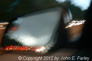
Hard to tell when you're in flight mode and can only see it in the mirror, but it sure looked like a funnel cloud to me. On cue, the weather radio alarmed and announced a tornado warning based on rotation over Caseyville - right where the lowering I saw was. And a spotter in the north part of O'Fallon, looking west, also reported a funnel cloud around the time of the picture above - so I think it was, but I'm not completely sure.
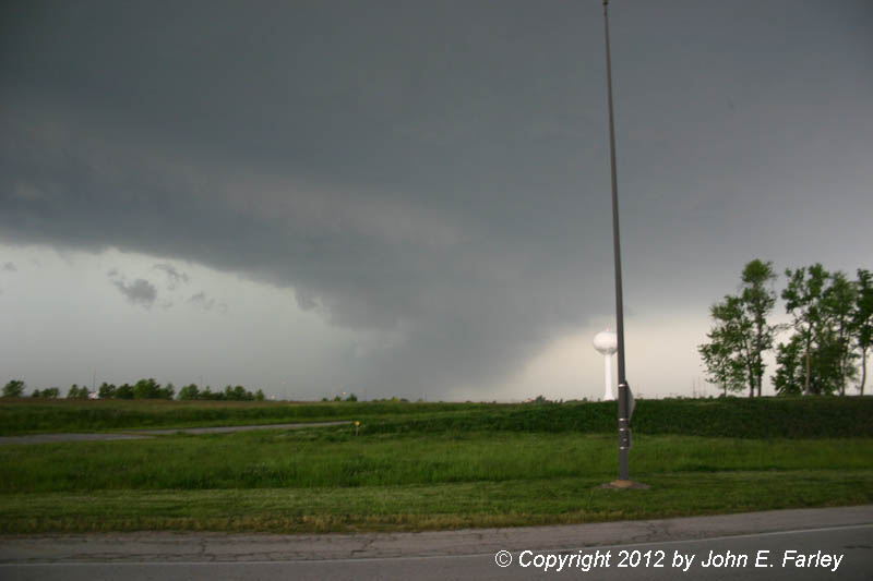
I wanted to stop and look at the storm, but in the congested areas of Fairview Heights, O'Fallon, and Scott AFB, I knew I would be caught in traffic and overrun by the storm. I thought about trying to find a gas station canopy and let it move over and observe the hail, but I did not because 1) I thought they might all be taken as people raced to get their cars out of the hail, and 2) I really wanted to stay ahead of the storm for a while and observe its structure. So I continued on to Route 4, where Mid-America Airport would offer a clear view, and got this picture looking northwest as the storm pounded O'Fallon with up to 3.5-inch hail:
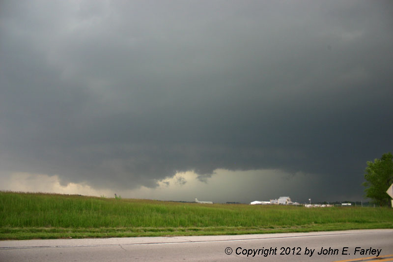
At this time the storm seemed to be cycling, with a new mesocyclone (the lowered area on the left side of the picture) forming southeast of the earlier one (the dark area on the right). A picture of the earlier meso taken a minute or two after the picture above can be seen here. The storm was still moving directly at me at 40-45 mph, so it was time to blast southeast again - this time the storm was close enough that I encountered more rain and prehaps a few small hailstones, but again I managed to stay ahead of the core, and was quickly clear of the precipitation. By this time the tornado warning that had been issued for the rotation over Caseyville had expired and been replaced by a severe thunderstorm warning. SVR warnings continued to be renewed for this storm for the rest of the time I was on it. The next stop I made was at the Albers exit, where I was enough ahead of the storm to be able to sit for maybe 5-10 minutes. It again seemed to be ramping up in intensity, and produced this interesting lowering, which was variously reported by different spotters as a funnel cloud or wall cloud:
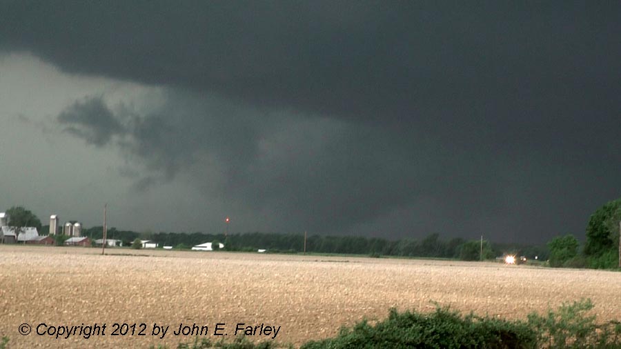
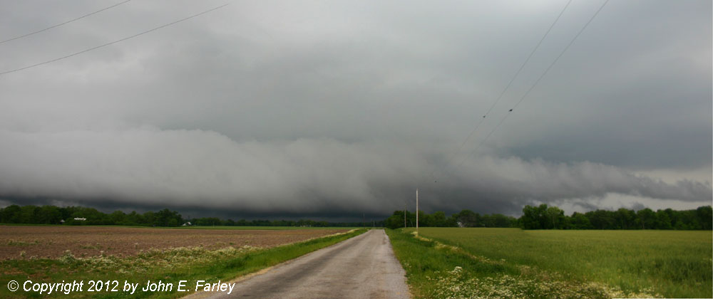
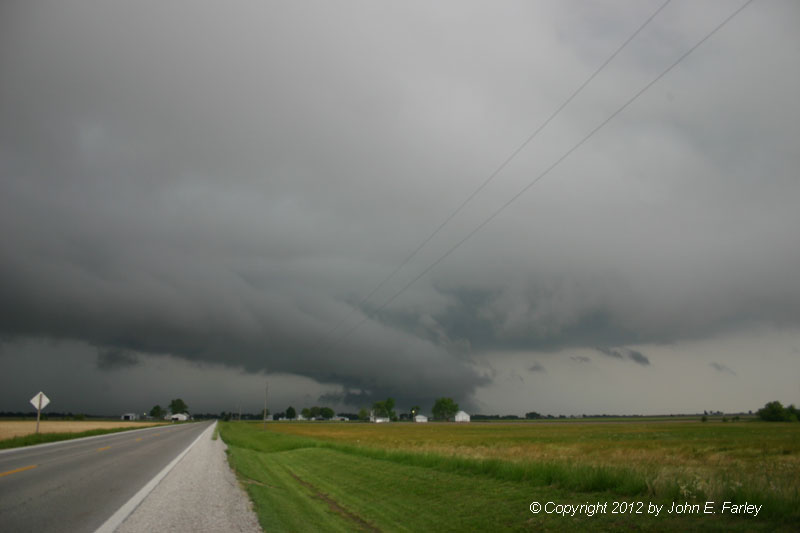
Another video capture of the same feature illuminated by a flash of lightning can be seen here. In the poor contrast I wasn't exactly what to call this feature, but was concerned enough about it that I simply called it in as a large lowering; it did become evident after it moved closer that it did not extend to the ground. With this feature coming directly at me and lightning striking within less than a mile, it was time to move down I-64 yet again. I tried stopping at the Okawville exit but there was no clear view from there, so I continued on down to the Nashville exit. This put me too far ahead of the storm for a good view of it, but I was able to double back west and set up along IL route 15 in time to watch the storm from the southeast as it hit Okawville with the largest hail reported with this storm, 4.5 inches. Here is a picture (with some of the top and bottom cropped) that I took with my wide-angle lens, which it required to get all the storm structure in one picture:

The storm had become more elongated by this time, and after passing over Okawville it began to weaken. I followed it back east toward Nashville, finally having the luxury of being able to watch it from a position where I was not about to be overrun by it. It started to look more organized one last time northwest of Nashville:
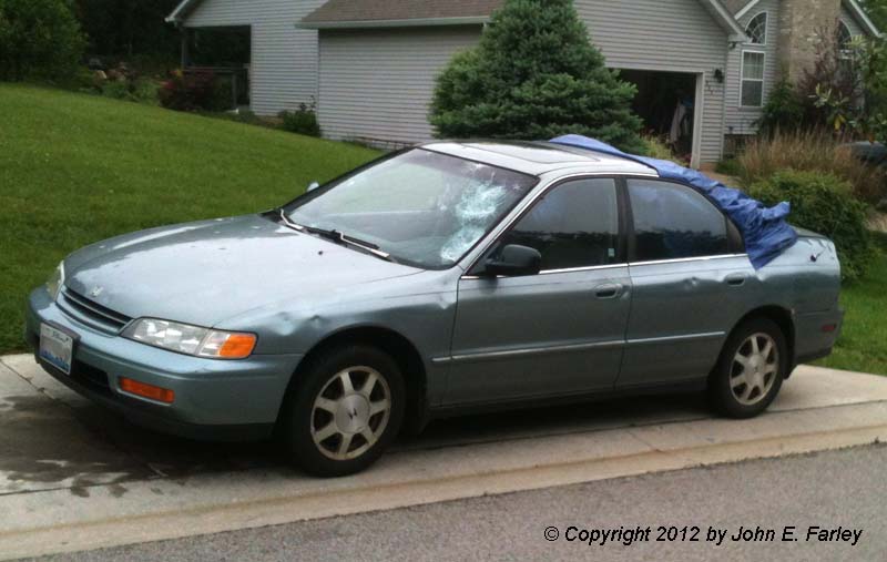
That was it, though. Both visually and on radar, the storm began to weaken, its energy perhaps being sapped by a new supercell that had popped up just to its west and was also now severe-warned. Since this new one to the west now seemed to be stronger than the original one, and since it was on the way home, I decided to double back west for an intercept. Although this storm was not as intense as the earlier one, it did produce 1-inch hail in Okawville. It had a very low and elongated base that looked like something of a hybrid between a wall cloud and shelf cloud, with an inflow tail coming in from the east - panorama picture here. Eventually, as it moved off to the east from Okawville, it took on more of an HP supercell appearance. This was pretty much the end of the chase for me. For a while now, another supercell that followed the same path as the earlier one had been tornado-warned over the city of St. Louis and into Illinois - my daughter even called for a radar update; I was able to assure her that the tornado-warned storm was not heading her direction - more in mine, actually. However, I figured that by the time I could get to that storm, even with it moving toward me, it would weaken as it moved into the cooler, wetter atmosphere that had been worked over by the earlier storms, and that is pretty much what happened. During a pit stop at a gas station just south of Lebanon, I heard stories of cars with their windshields and back windows broken - there were many, many of these, as it turns out. In fact, the next morning there was one parked down the street from me in Edwardsville that had been in the wrong place at the wrong time - had I not stayed out of the way of this storm, my car could well have looked like this one:
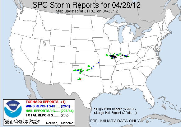
It's not too often you'll see this much black (the color for very large hail reports) on the daily reports map from SPC:
A listing of reports from the St. Louis NWS, including both severe and subsevere hail, wall cloud and funnel reports, etc. can be seen here. All in all, with the storm of the day moving through the metro area then right down the freeway that was the only option for quite a while to stay ahead of it - and doing so at 40-45 mph - this was not an easy chase! But it was worth it to see a storm of this magnitude, even if it did not produce a tornado - which was far better anyway, since if there had been one it would likely have happened in a very populated area. With the tragic tent collapse and all the hail damage, this storm was deadly and destructive as it was.
Total chase distance: Approximately 160 miles.
A Web page on this storm from the St. Louis National Weather Service can be seen here. This Web page includes discussion, photos, videos, radar images and maps showing the hail swaths from both waves of supercell storms that affected the St. Louis area.
Update, May 6, 2012: According to a report in today's Post-Dispatch, two insurance companies, State Farm and American Family, have reported about 30,000 claims for damage to autos and 15,000 claims for damage to buildings thus far. And these two companies only represent about 1/3 of the St. Louis area market. You can read the full Post-Dispatch article here
This page was last updated May 6, 2012.