
An unusually strong - below 29.00 inches surface low over Minnesota - storm system was moving through the Midwest. The system was negatively tilted, with extremely strong mid and upper level winds from the southwest over surface winds that would range from SSW in western IL to southerly in eastern IL ahead of a cold front/dryline that would push across Illinois late in the day. At first it looked like the system would move through too fast for daytime storms in IL, but by the night before, it began to look like the timing would be better.
My thinking late the night before, from my post on the Stormtrack forecast thread:
"It looks like both the WRF and the GFS have slowed down the eastward progress of the front, keeping much of southern and eastern IL in the warm sector, with good instability and shear. Not too much precip showing on the WRF in this area, but if storms get going they should have a good chance of rotation. I'd like to see a little more directional shear, but there is some, and the EHI values predicted by the WRF in southern and eastern IL and nearby parts of IN are pretty decent - 2.7 in Terre Haute, 3.0 in Mt. Vernon, and 3.6 in Evansville. So, if it looks in the morning like this is going to verify, I will likely be heading out. Good luck to all who do!" And the next morning, I wrote: "I am leaning toward an Effingham, IL target. Despite what SPC says about the possibility of initiation not occurring until dark, both the WRF and RUC do initiate storms in that area before dark. The clearing across much of IL now will hopefully help with that, and with storm initiation. Also, Effingham has good road connections in all directions, so if I need to shift from there, it should be easy."
A big plus for the chance of severe storms in Illinois was the fact that a warm front had pushed through overnight, driving the cloudiness north so that there would be good sunshine and heating during the day. There was some concern that the storms might quickly evolve into a squall line, which would favor straight line winds rather than tornadoes, but with the amount of speed shear, with some directional shear, it looked like the storms would at least start out to be supercells, though it was not clear how long they would stay that way.
The storm chase:
1:30 – 3:00 gas, lunch, data, waiting at Flying J, Effingham
3:30 - I got spare batteries for the Wx radio in the Flying J shop, and made one final data check. No watch yet, that I heard of, though apparently it was issued almost the minute I shut down my laptop and drove off the parking lot to head back west toward where storms were now initiating in a curved line from just WSW of St. Louis down into southeast Missouri. I figured I might intercept them somewhere around halfway back toward STL.
4:10 (approximate) - In Vandalia. I have now heard about red box for most of IL. I tried to get wiFi at 3 Vandalia motels for a radar update, but had no luck, wasting 15-20 minutes.
Finally, I gave up on WiFi and turned my attention to the Weather radio. I then heard about SVR warnings for Bond, southeast Madison, northeast St. Clair, and northwest Clinton Counties. This was based on a radar indication of a SVR storm with hail located over Scott AFB. This is around 4:25, possibly 4:30. The SVR warning was valid until 5:00. At first storm did not look impressive, mainly because I was not seeing the intense part of it, but 7 miles east of Greenville, I rounded a curve and saw a spectacular wall cloud and pronounced rainfoot. The storm probably was approaching Highland at this time.
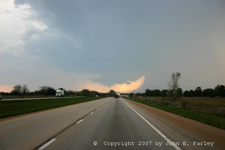
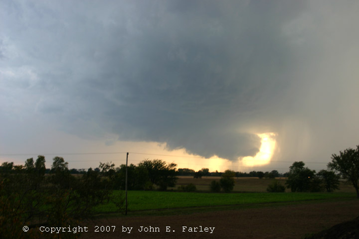
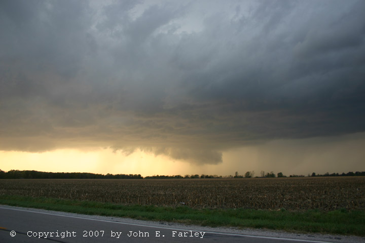
4:45-4:50 (approximate). I arrived in Greenville and took up a viewing spot near 127 & 70. I got this photo showing the dramatic rainfoot just after I stopped. After a few minutes it looked like precipitation (or maybe dust?) was being sucked back up into the wall cloud from the rainfoot, though it may have been a narrow precipitation shaft behind the wall cloud. This photo was likely taken around the time when wind damage is occurring in a mobile home park in Pierron. I watched the wall cloud for 10-20 minutes, until it got within a mile or two and I felt I had to move. During this time, the storm produced wind damage from Highland to Pierron. Here is a photo taken just before the storm reached Greenville:

5:10-5:15 Golfball hail and wind damage were occurring in Greenville as I bailed east. Even though I was driving at 70-75 mph to try to get ahead of the storm, it appeared to be staying even with me in my rear view mirror. I wanted to stop at Mulberry Grove, but there was no view at that exit due to trees, so I continued to the first Vandalia exit. By then, I had finally gained some on the storm.
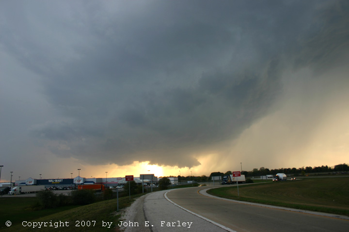
5:25 or so - Shortly after arriving in Vandalia, I heard a TOR warning based on a report of a funnel cloud near Mulberry Grove at 5:19. The local storm report shows an unconfirmed tornado reported there a minute later, which I have serious doubts about. I saw multiple funnel like lowerings under the wall cloud from a few minutes earlier to around the time of the warning, but they either lost their shape quickly or it was soon evident that they were scud. Here is a picture taken around this time, from the exit at the west edge of Vandalia:

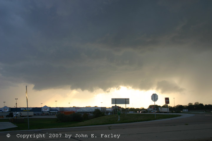
Here is a more wide-angle shot showing some of the storm structure at this time. I saw nothing at this time that I could confirm as a funnel cloud, much less a tornado, so I have doubts about these reports. Also, just after this, the wall cloud became elongated and looked like it was evolving into a shelf cloud, as the storm became more outflow dominant.
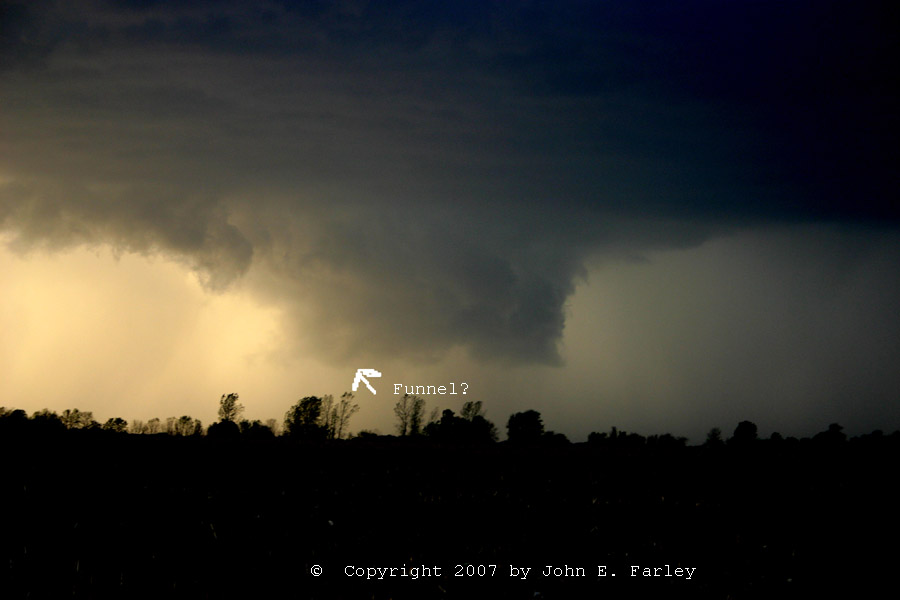
Around 5:30, I got back on highway and went an exit east to get on route 40, which parallels I-70 in that area, so I could follow the storm and stop as needed. I stopped to the watch storm 1 mile east of Brownstown. At first, the lowered area still looked elongated and outflow dominant. But around 5:35 or 5:40, the wall cloud tightened up again and, and now it looked like a tornado could be imminent:

I saw none, but one was reported by a spotter from 5:33-5:40, 4 miles northwest of Brownstown. Though I saw nothing that looked like a tornado, my photos do show a slightly lowered area, which could well have been a funnel cloud, under the wall cloud, along with a bit of an RFD notch poking in. An enhanced version of the above photo showing this feature can be seen here. Though it looked like there could have been a funnel, my video does not show any obvious tornado or clear rotation, though contrast is not as good as it was earlier, and there is some rain-wrapping. Still, based on the appearance of the wall cloud at this time, I am more inclined to believe the report of a tornado northwest of Brownstown than the earlier one near Mulberry Grove. If it was, I may have the tornado in my pictures, as I was too far away to see whether there was any dust or debris raised near the ground. Still, there was not condensation to the ground, and I certainly did not think at the time that a tornado was occuring. But since the contrast was not nearly as good as it was earlier, and the feature was partially rain-wrapped, I really cannot tell for sure . Nothing I could see when I looked at the video makes me change this thinking much.
By this time, it probably was around 5:45 or so. As the storm was about to get ahead of me again, I got back on I-70 at St. Elmo (5 miles or so east of where I stopped) and blasted east again. All the while, I was keeping my eye on another TOR-warned storm south of this one. I considered going after it at 2 or 3 points, but doubts about being able to get to it without a core punch keep me from doing so.
6:15? I find a spot to view the storm just south of Neoga, after a hair-raising run north on 57 from Effingham where I discovered there was no exit for 12 miles! In the meantime, at 6:02, while I was en route between Brownstown and Neoga, the mesonet recorded a hurricane-force 74 mph gust in Cowden, which is about 14 miles WNW of Effingham and 12 or 13 miles north of St. Elmo.
After I got through Effingham and was heading north on I-57, I thought the storm would overrun me, as it began to fill in between the 2 cells and look more like a squall line. (I really expected there to be an exit sooner than 12 miles when I headed north from Effingham, so I was getting pretty freaked out as the line surged toward me.) But despite the more linear nature of the storm, there was still a strong, distinct meso and wall cloud in the storm I had been chasing, which was now off to the W/NW of Neoga. I could see a big dark lowering, partly hidden in rain. I finally got to the exit, and managed to find a place where I could watch the storm from a mile or so south or Neoga from around 6:15 or so until I lost it in the dark as it passed north of Neoga, getting some video of the still-pronounced wall cloud and lightning.
Here is a video capture of the wall cloud and an apparently occluded and rain-wrapped lowering to its northeast illuminated by lightning:

This was taken from where I stopped a mile or so south of Neoga. Here is another video capture taken shortly later showing some in-cloud lightning, as the newer wall cloud also begins to wrap up in rain. Also, around this time, the next storm south, along with the line that had filled in between the two storms, abruptly died, leaving the storm I had been chasing as the tail-end storm. But it was too dark to pursue it any further.
Shortly after I gave up arond 6:30, the storm produced wind damage in Mattoon, a bit up I-57, at 6:40. It eventually moved to Lafayette, IN, where it apparently led to additional tornado warnings. Another chaser did report seeing a rotating wall cloud in Indiana as the storm passed SE of Danville, IL around 7 pm.
I got a bite to eat in Effingham, and headed for home. There were still some storms between Effingham and Edwardsville, and I skirted the north edge of an intensifying storm that first went SVR warned, then TOR warned near Carlyle Lake later on way home. I exited at Greenville and went a little south on 127 to see what I could see of the storm, and while I could see some strong updrafts illuminated by lightning to my east, the storm, which like the others was moving 50 mph or faster, was already too far east to see anything more than that.
All in all, this was a great October chase. The fact that the storm I chased moved nearly parallel to I-70 made it chaseable despite its rapid motion, and the wall cloud and rainfoot backlit by the setting sun were a sight to see! Pretty good for Illinois in October!
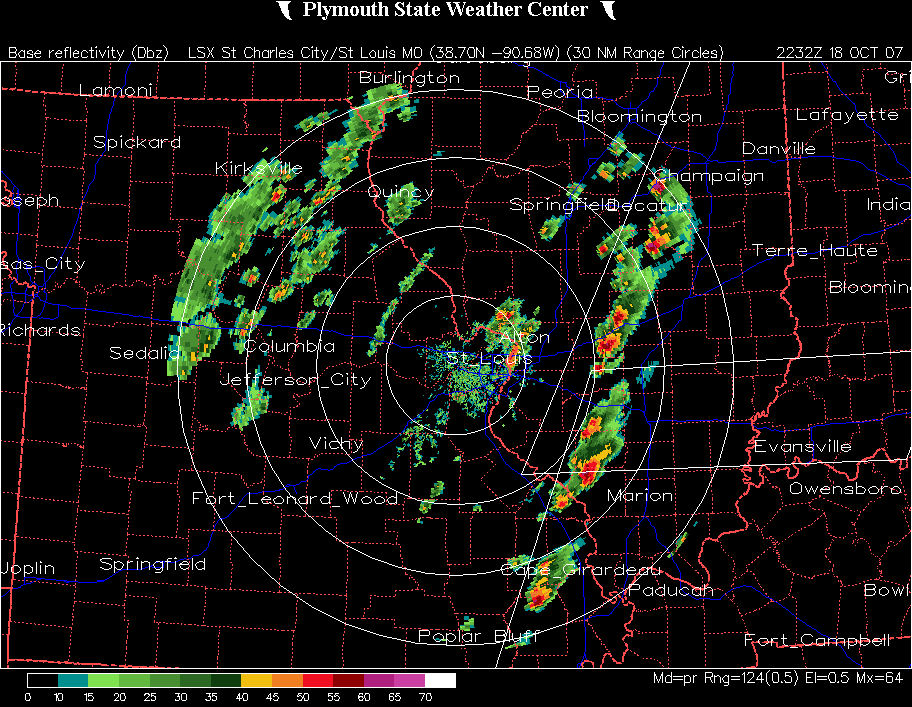
Here are two radar loops. In the first one, the storm I was on is the one that crosses I-70 to the ESE of St. Louis:
In the next one, the storm moves from just north of Vandalia until it moves out of the range of the radar after it crosses I-57 about due west of Terre Haute. Note that the other storm, to its immediate south, dies out as it approaches Effingham:
Here are local storm reports:
Return to Severe Weather Observation page